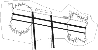
Vojens - Skrydstrup
Airport details
| Country | Denmark |
| State | Region of Southern Denmark |
| Region | EK |
| Airspace | Copenhagen Ctr |
| Municipality | Haderslev Municipality |
| Elevation | 130ft (40m) |
| Timezone | GMT +1 |
| Coordinates | 55.21701, 9.24852 |
| Magnetic var | |
| Type | land |
| Available since | X-Plane v10.40 |
| ICAO code | EKSP |
| IATA code | SKS |
| FAA code | n/a |
Communication
| Skrydstrup ATIS | 133.900 |
| Skrydstrup Tower | 118.275 |
| Skrydstrup Approach | 127.475 |
Approach frequencies
| ILS-cat-I | RW10L | 109.35 | 18.00mi |
| ILS-cat-I | RW28R | 109.35 | 18.00mi |
| 3° GS | RW10L | 109.35 | 18.00mi |
| 3° GS | RW28R | 109.35 | 18.00mi |
Runway info
Nearby beacons
| code | identifier | dist | bearing | frequency |
|---|---|---|---|---|
| VO | VOJENS/SKRYDSTRUP NDB | 0.9 | 73° | 321 |
| SKR | VOJENS/SKRYDSTRUP VORTAC | 1.3 | 289° | 110.40 |
| VAM | DME | 13.6 | 21° | 110.05 |
| KD | KOLDING NDB | 13.9 | 21° | 357 |
| EJ | ESBJERG NDB | 27 | 301° | 400 |
| ESE | DME | 29.8 | 294° | 116.60 |
| ALS | ALSIE VOR | 31.7 | 113° | 114.70 |
| HP | ESBJERG NDB | 33.5 | 289° | 376 |
| SLT | WESTERLAND/SYLT NDB | 36 | 247° | 387 |
| WES | DME-ILS | 36.2 | 251° | 111.50 |
| SWG | SCHLESWIG TACAN | 46.1 | 160° | 111.80 |
| VJ | STAUNING NDB | 54.1 | 313° | 328 |
| HNT | HOHN TACAN | 55.3 | 162° | 115.30 |
| HN | HOHN NDB | 55.4 | 155° | 344 |
| LME | DME | 55.5 | 311° | 115.35 |
| AU | STAUNING NDB | 56.1 | 310° | 346 |
| KIL | KIEL-HOLTENAU NDB | 58.7 | 134° | 353 |
| KHD | (HOLTENAU) DME-ILS | 59.1 | 133° | 109.50 |
Instrument approach procedures
| runway | airway (heading) | route (dist, bearing) |
|---|---|---|
| RW10L | GORNO (112°) | GORNO TISET (5mi, 172°) 2000ft |
| RW10L | NIREK (89°) | NIREK TISET (5mi, 51°) 2000ft |
| RNAV | TISET 2000ft SP101 (6mi, 99°) 2000ft SP10L (6mi, 99°) 176ft SP10E (7mi, 99°) 2000ft SP10E (turn) 2000ft | |
| RW28R | BURUX (290°) | BURUX DINUT (5mi, 353°) 2000ft |
| RW28R | DINUT (278°) | DINUT 2000ft |
| RW28R | OLUTU (268°) | OLUTU DINUT (5mi, 231°) 2000ft |
| RNAV | DINUT 2000ft SP281 (6mi, 279°) 2000ft SP28R (6mi, 279°) 182ft SP28W (7mi, 279°) 2000ft SP28W (turn) 2000ft |
Disclaimer
The information on this website is not for real aviation. Use this data with the X-Plane flight simulator only! Data taken with kind consent from X-Plane 12 source code and data files. Content is subject to change without notice.

