Airports for X-Plane offers a convenient way to explore airports and their related communication information for the X-Plane flight simulator. It only uses data from the X-Plane flight simulator itself, and is therefore more reliable than the data that comes from real aviation websites. You can search for airports by using the ICAO code, or browse for airports per country and state. The information displayed is categorized by airport details, runway information, airport communication, approach frequencies (ILS and Glidepath details), details of nearby beacons, SIDs, STARs and approach procedures.

air traffic control seaplanes airdrome flight asphalt corporation southwest outskirts airline government flown airbus flights terminal kennedy airplane airstrip landing area warfare control tower

Samsø - Samsoe

Airport details

CountryDenmark
StateCentral Denmark Region
RegionEK
AirspaceCopenhagen Ctr
MunicipalitySamsø Municipality
Elevation0ft (0m)
TimezoneGMT +1
Coordinates55.88986, 10.61375
Magnetic var
Typeland
Available sinceX-Plane v10.40
ICAO codeEKSS
IATA coden/a
FAA coden/a

Communication

Samsoe Samsoe Radio123.500
Samsoe Copenhagen Information129.475
Nearby Points of Interest:
Vesborg
-
Kysing Kirkeruin
-
Randlev Præstegård
-
Gylling Præstegård
-
Gylling Runestone
-
Rodsteenseje
-
Åkær
-
Ole Rømer Observatory
-
Old townhall of Kalundborg
-
Den gamle Latinskole
-
Præstegade 23
-
Kaalund Kloster
-
Trods Katholm
-
Horsens Fjord
-
Aarhus Custom House
-
Aarhus City Hall
-
Bøgebjerg
-
Ridehuset
-
Aarhus Courthouse
-
Business- and Agricultural Bank of Jutland
-
Smykkeskrinet
-
Mønsted's House
-
Tyrrestrup
-
Det norske hus
-
Bådstedgård

Runway info

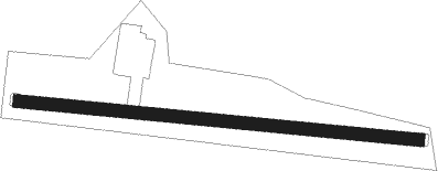
Runway 10 / 28
 length901m (2956ft)
 bearing96° / 276°
 width30m (98ft)
 surfacegrass

Airport layout


Parking locations

Nearby beacons

codeidentifierdistbearingfrequency
ODNODIN VOR/DME18.5173°115.50
FEODENSE NDB22.7202°423
TLAARHUS NDB24.6384
TNOTRANO VOR/DME28.698°117.40
ALSALSIE VOR62.7212°114.70

Disclaimer

The information on this website is not for real aviation. Use this data with the X-Plane flight simulator only! Data taken with kind consent from X-Plane 12 source code and data files. Content is subject to change without notice.