Kirke Vaerlose - Vaerlose Ab
Airport details
| Country | Denmark |
| State | Capital Region of Denmark |
| Region | EK |
| Airspace | Copenhagen Ctr |
| Municipality | Furesø Municipality |
| Elevation | 58ft (18m) |
| Timezone | GMT +1 |
| Coordinates | 55.77152, 12.30038 |
| Magnetic var | |
| Type | land |
| Available since | X-Plane v10.40 |
| ICAO code | EKVL |
| IATA code | n/a |
| FAA code | n/a |
Communication
Nearby Points of Interest:
Edelgave
-Fæstningskanalen
-Christianelyst
-Marienborg
-Rudersdal Town Hall
-Gramlille
-Vestvolden
-Lyngby Townhall
-Moyel House
-Carlsminde
-Ørholm
-Rødovre Town Hall
-Schæffergården
-Favrholm
-De Ovale Haver
-K.B. Hallen
-Par force hunting landscape in North Zealand
-Store Dyrehave
-Raadvad Mølle
-Søholm
-Lygten Station
-P. Andersens Vandtårn
-Holger Petersens Tekstilfabrik
-Frederiksborg Latin School
-4. Maj Kollegiet
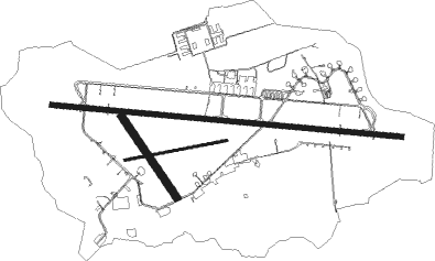
Runway info
Runway 10 / 28  | ||
| length | 2998m (9836ft) | |
| bearing | 95° / 275° | |
| width | 46m (151ft) | |
| surface | asphalt | |
| displ threshold | 270m (886ft) / 270m (886ft) | |
| Runway 08 / 26 | ||
| length | 884m (2900ft) | |
| bearing | 86° / 266° | |
| width | 20m (66ft) | |
| surface | grass | |
| Runway 15 / 33 | ||
| length | 825m (2707ft) | |
| bearing | 135° / 315° | |
| width | 60m (197ft) | |
| surface | grass | |
Nearby beacons
| code | identifier | dist | bearing | frequency |
|---|---|---|---|---|
| BEL | DME | 7 | 275° | 114.65 |
| RK | ROSKILDE (COPENHAGEN) NDB | 13.5 | 244° | 368 |
| KAS | KASTRUP (COPENHAGEN) VOR/DME | 15.1 | 120° | 112.50 |
| SVD | DME | 25.5 | 35° | 116.20 |
| TNO | TRANO VOR/DME | 29 | 270° | 117.40 |
| KOR | KORSA VOR/DME | 30.2 | 244° | 112.80 |
| LJU | LJUNGBYHED VOR/DME | 35.6 | 71° | 113.40 |
| AH | ANGELHOLM NDB | 35.8 | 51° | 417 |
| LB | ANGELHOLM NDB | 37.9 | 39° | 370 |
| CDA | CODAN VOR/DME | 46.3 | 174° | 114.90 |
| MF | HALMSTAD NDB | 55.5 | 30° | 421 |
Disclaimer
The information on this website is not for real aviation. Use this data with the X-Plane flight simulator only! Data taken with kind consent from X-Plane 12 source code and data files. Content is subject to change without notice.