Aalborg
Airport details
| Country | Denmark |
| State | North Denmark Region |
| Region | EK |
| Airspace | Copenhagen Ctr |
| Municipality | Aalborg |
| Elevation | 5ft (2m) |
| Timezone | GMT +1 |
| Coordinates | 57.08680, 9.86408 |
| Magnetic var | |
| Type | land |
| Available since | X-Plane v10.30 |
| ICAO code | EKYT |
| IATA code | AAL |
| FAA code | n/a |
Communication
| Aalborg ATIS | 120.475 |
| Aalborg Tower | 118.300 |
| Aalborg Approach | 123.975 |
| Aalborg ARR | 120.700 |
Approach frequencies
| ILS-cat-III | RW26R | 111.55 | 18.00mi |
| ILS-cat-I | RW08L | 109.9 | 18.00mi |
| 3° GS | RW26R | 111.55 | 18.00mi |
| 2.7° GS | RW08L | 109.9 | 18.00mi |
Nearby Points of Interest:
Jørgen Olufsen's House
-Aalborg Post og Telegraf
-Jens Bang's House
-Lundby Bakker Hellekiste
-Ferslev-stenen 1
-Hellighøje
-Jetsmark stone
-Gunderup-stenen 2
-Gunderup Runestone 1
-Lundbæk
-Hune stone
-Suldrup-stenen
-Lyngby-stenen
-Kongstedlund
-Skivum Runic Stone
-Lille Vildmose
-langdysse ved Skræm
-Rold Skov
-Giver runestone
-Ravnkilde-stenen 1
-Aggersborggård
-Fuglsig
-Flejsborg-stenen
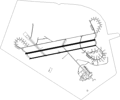
Runway info
Runway 08L / 26R  | ||
| length | 2646m (8681ft) | |
| bearing | 86° / 266° | |
| width | 45m (148ft) | |
| surface | asphalt | |
| blast zone | 255m (837ft) / 222m (728ft) | |
| Runway 08R / 26L | ||
| length | 2542m (8340ft) | |
| bearing | 86° / 266° | |
| width | 23m (75ft) | |
| surface | asphalt | |
| blast zone | 150m (492ft) / 150m (492ft) | |
Nearby beacons
| code | identifier | dist | bearing | frequency |
|---|---|---|---|---|
| AAL | AALBORG VORTAC | 4.4 | 83° | 116.70 |
| SD | SINDAL NDB | 26.5 | 35° | 339 |
| TL | AARHUS NDB | 53.3 | 136° | 384 |
| KAR | KARUP TACAN | 55.2 | 227° | 110 |
Instrument approach procedures
| runway | airway (heading) | route (dist, bearing) |
|---|---|---|
| RW08L | GIPUG (88°) | GIPUG 2300ft |
| RW08L | KUDEV (74°) | KUDEV 2300ft GIPUG (5mi, 347°) 2000ft |
| RW08L | TOSVO (100°) | TOSVO 2000ft GIPUG (5mi, 167°) 2000ft |
| RNAV | GIPUG 2000ft YT081 (5mi, 86°) 2000ft EKYT (7mi, 89°) 48ft YT083 (4mi, 83°) YT083 (turn) 2000ft | |
| RW26R | BAKIT (265°) | BAKIT 2300ft |
| RW26R | OKPOT (250°) | OKPOT 2000ft BAKIT (5mi, 168°) 2000ft |
| RW26R | VABUT (279°) | VABUT 2300ft BAKIT (5mi, 348°) 2000ft |
| RNAV | BAKIT 2000ft YT261 (4mi, 267°) 2000ft EKYT (7mi, 264°) 49ft YT263 (3mi, 273°) BAKIT (13mi, 86°) 3000ft BAKIT (turn) 3000ft |
Disclaimer
The information on this website is not for real aviation. Use this data with the X-Plane flight simulator only! Data taken with kind consent from X-Plane 12 source code and data files. Content is subject to change without notice.