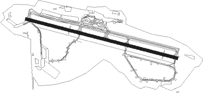
Målselv - Bardufoss
Airport details
| Country | Norway |
| State | Troms |
| Region | EN |
| Airspace | Polaris Ctr |
| Municipality | Målselv |
| Elevation | 251ft (77m) |
| Timezone | GMT +1 |
| Coordinates | 69.05583, 18.54028 |
| Magnetic var | |
| Type | land |
| Available since | X-Plane v10.40 |
| ICAO code | ENDU |
| IATA code | BDU |
| FAA code | n/a |
Communication
| Bardufoss ATIS | 129.725 |
| Bardufoss Tower | 118.100 |
| Bardufoss Tower | 122.100 |
| Bardufoss Approach | 118.800 |
| Bardufoss Approach | 125.850 |
Approach frequencies
| LOC | RW10 | 110.3 | 18.00mi |
| ILS-cat-I | RW28 | 108.7 | 18.00mi |
| 3.7° GS | RW28 | 108.7 | 18.00mi |
Nearby beacons
| code | identifier | dist | bearing | frequency |
|---|---|---|---|---|
| BAR | BARDUFOSS TACAN | 1.1 | 102° | 113.40 |
| BDF | BARDUFOSS VOR/DME | 1.6 | 277° | 114.20 |
| TIL | TILLER NDB | 12.4 | 96° | 350 |
| SJA | SENJA NDB | 16.7 | 278° | 414 |
| KBV | KOBBE (TROMSO) NDB | 27.6 | 32° | 283 |
| TRO | TROMSO VOR/DME | 40 | 35° | 113.80 |
| KV | KVALSUND (TROMSO) NDB | 46.4 | 31° | 362 |
Departure and arrival routes
| Transition altitude | 7000ft |
| SID end points | distance | outbound heading | |
|---|---|---|---|
| RW10 | |||
| PIGA2J | 30mi | 77° | |
| RIXE1X, RIXE1J | 42mi | 98° | |
| POBE1J | 36mi | 135° | |
| AMIM1J | 85mi | 241° | |
| LAVN1X | 23mi | 254° | |
| SJA1J | 17mi | 278° | |
| RW28 | |||
| PIGA2K | 30mi | 77° | |
| AMIM1K | 85mi | 241° | |
| LAVN1Y | 23mi | 254° | |
| SJA1K, SJA1Y | 17mi | 278° | |
| ROSK1Y | 20mi | 319° | |
| STAR starting points | distance | inbound heading | |
|---|---|---|---|
| RW10 | |||
| XAPA2N | 35.1 | 72° | |
| ANDO6S | 26.1 | 83° | |
| BARV1N | 30.9 | 89° | |
| ROSK3S | 19.7 | 139° | |
| TULD6S | 14.5 | 246° | |
| REPG1N | 42.0 | 262° | |
| RW28 | |||
| XAPA2P | 35.1 | 72° | |
| LAVN7T | 23.0 | 74° | |
| BARV1P | 30.9 | 89° | |
| TRO6T | 40.0 | 215° | |
| REPG1P | 42.0 | 262° | |
Instrument approach procedures
| runway | airway (heading) | route (dist, bearing) |
|---|---|---|
| RW10 | OSLOL (105°) | OSLOL 5000ft VAXEX (5mi, 223°) 5000ft |
| RW10 | XENOK (90°) | XENOK 5000ft VAXEX (5mi, 43°) 5000ft |
| RNAV | VAXEX 5000ft DU400 (5mi, 97°) 4000ft ENDU (10mi, 97°) 303ft DU403 (10mi, 97°) DU404 (12mi, 92°) TIL (9mi, 272°) 7000ft TIL (turn) 7000ft | |
| RW28 | OGOLO (283°) | OGOLO 6500ft ELROR (6mi, 354°) 6500ft |
| RW28 | TULNO (269°) | TULNO 6500ft ELROR (8mi, 245°) 6500ft |
| RNAV | ELROR 6500ft DU410 (4mi, 277°) 5200ft DU411 (13mi, 276°) 269ft DU412 (3mi, 276°) DU413 (20mi, 282°) SJA (6mi, 110°) 5000ft SJA (turn) 5000ft |
Holding patterns
| STAR name | hold at | type | turn | heading* | altitude | leg | speed limit |
|---|---|---|---|---|---|---|---|
| ANDO6S | SJA | FIX | left | 284 (104)° | > 5000ft | 1.0min timed | ICAO rules |
| LAVN7T | TIL | FIX | left | 100 (280)° | > 6500ft | 1.0min timed | ICAO rules |
| ROSK3S | SJA | FIX | left | 284 (104)° | > 5000ft | 1.0min timed | ICAO rules |
| RUST6T | TIL | FIX | left | 100 (280)° | > 6500ft | 1.0min timed | ICAO rules |
| SIRM6T | TIL | FIX | left | 100 (280)° | > 6500ft | 1.0min timed | ICAO rules |
| TRO6T | TIL | FIX | left | 100 (280)° | > 6500ft | 1.0min timed | ICAO rules |
| TULD6S | SJA | FIX | left | 284 (104)° | > 5000ft | 1.0min timed | ICAO rules |
| *) magnetic outbound (inbound) holding course | |||||||
Disclaimer
The information on this website is not for real aviation. Use this data with the X-Plane flight simulator only! Data taken with kind consent from X-Plane 12 source code and data files. Content is subject to change without notice.
