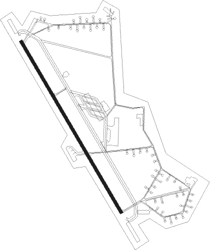
Ørland - Orland
Airport details
| Country | Norway |
| State | Sør-Trøndelag |
| Region | EN |
| Airspace | Polaris Ctr |
| Municipality | Ørland |
| Elevation | 26ft (8m) |
| Timezone | GMT +1 |
| Coordinates | 63.69889, 9.60389 |
| Magnetic var | |
| Type | land |
| Available since | X-Plane v10.40 |
| ICAO code | ENOL |
| IATA code | OLA |
| FAA code | n/a |
Communication
| ORLAND Tower | 118.250 |
| ORLAND Tower | 122.100 |
| ORLAND Tower | 118.700 |
| ORLAND ARR | 126.200 |
| ORLAND Approach | 118.250 |
Approach frequencies
| ILS-cat-I | RW15 | 109.3 | 18.00mi |
| ILS-cat-I | RW33 | 108.3 | 18.00mi |
| 3.3° GS | RW33 | 108.3 | 18.00mi |
| 3° GS | RW15 | 109.3 | 18.00mi |
Nearby Points of Interest:
Ørland Main Air Station
-Brettingen fort
-Hysnes fort
-Vallersund Gård
-Rein Abbey
-Stadsbygd prestegård
-Rødberg tåkeklokke
-Stykketin kalliopiirrokset
Nearby beacons
| code | identifier | dist | bearing | frequency |
|---|---|---|---|---|
| ORL | ORLAND TACAN | 1.1 | 132° | 111.40 |
| UTH | UTHAUG NDB | 1.5 | 312° | 366 |
| TAR | TARVA NDB | 8.9 | 305° | 349 |
Departure and arrival routes
| Transition altitude | 7000ft |
| SID end points | distance | outbound heading | |
|---|---|---|---|
| RW15 | |||
| EKRU1C | 47mi | 62° | |
| UTUN1C | 60mi | 128° | |
| UVEP1C, UVEP1W | 21mi | 233° | |
| RW33 | |||
| EKRU2D | 47mi | 62° | |
| UTUN2D | 60mi | 128° | |
| UVEP1D, UVEP2X | 21mi | 233° | |
| STAR starting points | distance | inbound heading | |
|---|---|---|---|
| RW15 | |||
| GEPL2N | 46.1 | 230° | |
| UTUN1N | 59.9 | 308° | |
| NELS1N | 35.4 | 357° | |
| RW33 | |||
| GEPL2P | 46.1 | 230° | |
| UTUN1P | 59.9 | 308° | |
| NELS1P | 35.4 | 357° | |
Instrument approach procedures
| runway | airway (heading) | route (dist, bearing) |
|---|---|---|
| RW15-X | SUKES (169°) | SUKES 3000ft GOKTA (5mi, 240°) 2000ft |
| RW15-X | VAVON (108°) | VAVON 3000ft GOKTA (5mi, 78°) 2000ft |
| RNAV | GOKTA 2000ft OL410 (4mi, 132°) 1500ft ENOL (5mi, 132°) 69ft OL411 (2mi, 132°) TAR (11mi, 306°) TAR (turn) 3000ft | |
| RW15-Z | SUKES (169°) | SUKES 3000ft GOKTA (5mi, 240°) 2000ft |
| RW15-Z | VAVON (108°) | VAVON 3000ft GOKTA (5mi, 78°) 2000ft |
| RNAV | GOKTA 2000ft INSIS (4mi, 132°) 1500ft ENOL (5mi, 132°) 69ft (3849mi, 189°) 500ft TAR (3856mi, 8°) TAR (turn) 3000ft | |
| RW33-X | DILRU (292°) | DILRU 5000ft UTPIP (5mi, 258°) 3800ft |
| RW33-X | NAXUT (346°) | NAXUT 6000ft UTPIP (5mi, 65°) 3800ft |
| RNAV | UTPIP 3800ft OL506 (5mi, 313°) 2700ft ENOL (8mi, 312°) 80ft OL505 (13mi, 312°) UTH (12mi, 132°) 4000ft | |
| RW33-Z | DILRU (292°) | DILRU 5000ft UTPIP (5mi, 258°) 3800ft |
| RW33-Z | NAXUT (346°) | NAXUT 6000ft UTPIP (5mi, 65°) 3800ft |
| RNAV | UTPIP 3800ft OL503 (4mi, 313°) 2700ft ENOL (8mi, 312°) 80ft (3849mi, 189°) 4000ft |
Holding patterns
| STAR name | hold at | type | turn | heading* | altitude | leg | speed limit |
|---|---|---|---|---|---|---|---|
| GEPL2N | GEPLO | VHF | right | 35 (215)° | > 20000ft | 1.0min timed | ICAO rules |
| GEPL2P | EMPES | VHF | right | 358 (178)° | > 5000ft | 1.0min timed | ICAO rules |
| GEPL2P | GEPLO | VHF | right | 35 (215)° | > 20000ft | 1.0min timed | ICAO rules |
| NELS1P | NAXUT | VHF | left | 220 (40)° | > 6000ft | 1.0min timed | ICAO rules |
| NELS1P | NELSU | VHF | right | 253 (73)° | > 7000ft | 1.0min timed | ICAO rules |
| *) magnetic outbound (inbound) holding course | |||||||
Disclaimer
The information on this website is not for real aviation. Use this data with the X-Plane flight simulator only! Data taken with kind consent from X-Plane 12 source code and data files. Content is subject to change without notice.