Barrhead
Airport details
| Country | Canada |
| State | Alberta |
| Region | |
| Airspace | Edmonton Ctr |
| Municipality | County of Barrhead |
| Elevation | 2121ft (646m) |
| Timezone | GMT -7 |
| Coordinates | 54.09686, -114.44695 |
| Magnetic var | |
| Type | land |
| Available since | X-Plane v10.40 |
| ICAO code | EP3 |
| IATA code | n/a |
| FAA code | n/a |
Communication
| Barrhead CTAF | 123.200 |
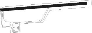
Runway info
| Runway 07 / 25 | ||
| length | 1061m (3481ft) | |
| bearing | 90° / 270° | |
| width | 30m (100ft) | |
| surface | asphalt | |
Nearby beacons
| code | identifier | dist | bearing | frequency |
|---|---|---|---|---|
| EB | NAMAO (EDMONTON) NDB | 43.3 | 113° | 256 |
| 4O | SWAN HILLS NDB | 48.7 | 301° | 251 |
| ZET | DEVON (EDMONTON) NDB | 52.4 | 134° | 292 |
| 3M | DRAYTON VALLEY NDB | 53 | 212° | 385 |
| ZZD | CALMAR (EDMONTON) NDB | 57.8 | 137° | 308 |
| YEG | EDMONTON VOR/DME | 58.4 | 148° | 117.60 |
| ZAB | LEDUC (EDMONTON) NDB | 61.5 | 132° | 215 |
Disclaimer
The information on this website is not for real aviation. Use this data with the X-Plane flight simulator only! Data taken with kind consent from X-Plane 12 source code and data files. Content is subject to change without notice.