Bezmiechowa Gorna - Bezmiechowa
Airport details
| Country | Poland |
| State | Subcarpathian Voivodeship |
| Region | |
| Airspace | Warsaw Ctr |
| Municipality | Bezmiechowa Górna |
| Elevation | 1475ft (450m) |
| Timezone | GMT +1 |
| Coordinates | 49.51032, 22.40672 |
| Magnetic var | |
| Type | land |
| Available since | X-Plane v10.40 |
| ICAO code | EP66 |
| IATA code | n/a |
| FAA code | n/a |
Communication
| Bezmiechowa Kwadrat | 122.800 |
Nearby Points of Interest:
Cerkiew Soboru Bogurodzicy w Paszowej
-Kościół św. Stanisława Biskupa w Uhercach Mineralnych
-Church of the Nativity of the Virgin Mary in Wańkowa
-Manor house in Bykowce
-Church of the Assumption in Średnia Wieś
-Our Lady of Perpetual Help church in Kuźmina
-Blessed Maria Teresa Ledóchowska church in Ustrzyki Dolne-Strwiążyk
-Cemetery in Nowotaniec
-the former Orthodox Church of St. Paraskeva
-39 Zielona Street in Sanok
-2 Zamkowa Street in Sanok
-Old town hall in Sanok
-14 Rynek Street in Sanok
-18 Rynek Street in Sanok
-16 Zamkowa Street in Sanok
-11 Sanowa Street in Sanok
-Dom Mansjonarzy in Sanok
-30 Zamkowa Street in Sanok
-5 Kościuszki Street in Sanok
-16 Sobieskiego Street in Sanok
-2 Lenartowicza Street in Sanok
-17 Daszyńskiego Street in Sanok
-6 Kazimierza Wielkiego Street in Sanok
-Apteka Kawskich
-1 2 Pułku Strzelców Podhalańskich in Sanok
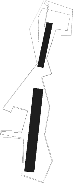
Runway info
Runway 01 / 19  | ||
| length | 612m (2008ft) | |
| bearing | 16° / 196° | |
| width | 80m (262ft) | |
| surface | grass | |
| Runway 02 / 20 | ||
| length | 324m (1063ft) | |
| bearing | 24° / 204° | |
| width | 50m (164ft) | |
| surface | grass | |
Nearby beacons
| code | identifier | dist | bearing | frequency |
|---|---|---|---|---|
| RSW | LUKAWIEC VOR/DME | 37.4 | 335° | 110.60 |
| VI | VERHNIE NDB | 42.3 | 132° | 334 |
| DUB | DME | 51.1 | 238° | 108.65 |
| UO | UZHHOROD NDB | 53 | 189° | 645 |
| UZH | DME | 53 | 189° | 115.65 |
| SR | SEREDNIE NDB | 59.5 | 174° | 690 |
Disclaimer
The information on this website is not for real aviation. Use this data with the X-Plane flight simulator only! Data taken with kind consent from X-Plane 12 source code and data files. Content is subject to change without notice.