Airports for X-Plane offers a convenient way to explore airports and their related communication information for the X-Plane flight simulator. It only uses data from the X-Plane flight simulator itself, and is therefore more reliable than the data that comes from real aviation websites. You can search for airports by using the ICAO code, or browse for airports per country and state. The information displayed is categorized by airport details, runway information, airport communication, approach frequencies (ILS and Glidepath details), details of nearby beacons, SIDs, STARs and approach procedures.

near aviation newark airport terminal plane airborne airport southwest airbase airfield aircraft local government capital airspace buildings air traffic control station commuter regional frankfurt airport

Nowodwór - Ulez

Airport details

CountryPoland
StateLublin Voivodeship
Region
AirspaceWarsaw Ctr
MunicipalityUłęż
Elevation560ft (171m)
TimezoneGMT +1
Coordinates51.62323, 22.09384
Magnetic var
Typeland
Available sinceX-Plane v10.40
ICAO codeEP71
IATA coden/a
FAA coden/a

Communication

No airport communication available for EP71
Nearby Points of Interest:
Manor in Stare Zadybie
-
Saints Catherine and Florian Church, Gołąb
-
Mogiła Berka Joselewicza
-
Sacred Heart church in Wojcieszków
-
Saint Anne church in Końskowola
-
Town Hall in Żelechów
-
World War I Cemetery in Kurów
-
Manor in Wilczyska
-
Church of the Transfiguration in Firlej
-
Holy Spirit church in Markuszów
-
Kościół Trójcy Świętej w Gończycach
-
Kościół św. Anny w Zwoli Poduchownej
-
Church of the Visitation in Miastków Kościelny
-
Kazimierz Dolny Castle
-
Kazimierz Dolny
-
Saint Anne church in Kazimierz Dolny
-
Kościół Świętego Jana Chrzciciela w Górznie
-
Kościół św. Stefana w Policznie
-
Stefan Żeromski Museum in Nałęczów
-
Villa Oktawia in Nałęczów
-
Villa Podgórze in Nałęczów
-
Sanatorium Książę Józef
-
Jewish cemetery in Kozienice
-
Church of the Assumption in Maciejowice
-
7 Górskiego Street in Nałęczów

Runway info

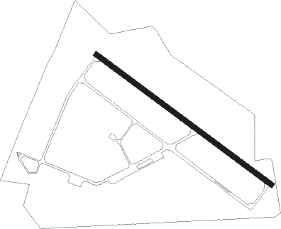
Runway 13 / 31
 length1387m (4551ft)
 bearing118° / 298°
 width32m (106ft)
 surfaceasphalt

Airport layout


Nearby beacons

codeidentifierdistbearingfrequency
NDEDEBLIN NDB7.7236°465
NDDEBLIN NDB8.1245°366
TDNDEBLIN TACAN8.5251°108.80
NEDEBLIN NDB9.2255°366
NEDDEBLIN NDB10.6261°465
SIESIEDLCE VOR/DME32.111°114.70
SWISWIDNIK VOR/DME32.1123°112.20
NRARADOM NDB33.1255°328
NRRADOM NDB34.7255°313
NFMINSK MAZOWIECKI NDB37.4325°282
TMMMINSK MAZOWIECKI TACAN37.7323°117.05
LINDME39.4288°113.10

Disclaimer

The information on this website is not for real aviation. Use this data with the X-Plane flight simulator only! Data taken with kind consent from X-Plane 12 source code and data files. Content is subject to change without notice.