Airports for X-Plane offers a convenient way to explore airports and their related communication information for the X-Plane flight simulator. It only uses data from the X-Plane flight simulator itself, and is therefore more reliable than the data that comes from real aviation websites. You can search for airports by using the ICAO code, or browse for airports per country and state. The information displayed is categorized by airport details, runway information, airport communication, approach frequencies (ILS and Glidepath details), details of nearby beacons, SIDs, STARs and approach procedures.
metro airport check-in passengers city airbase airplane airfield traffic pattern bus newark nation terminal airbus military near airliner outskirts landing area taxiway landing airdock
War cemetery for German soldiers from World War I in Ełk
-
World War I cemetery for Russian soldiers in Elk
-
Catholic cemetery in Ełk
-
Building of the Ełku Seminary
-
Bridge over Ełckie Lake
-
Ełk Castle
-
Boundary marker in Bogusze
-
Roman Catholic Cemetery in Suwałki
-
Kościół Świętej Trójcy w Suwałkach
-
Suwałki Town Hall
-
World War I cemetery in Rutka
-
12 Szkolna Street in Grajewo
-
Molenna w Suwałkach
-
Cmentarz parafialny w Grajewie
-
Kasyno oficerskie w Grajewie
-
Augustów Canal
-
Kościół św. Stanisława Kostki w Pozezdrzu
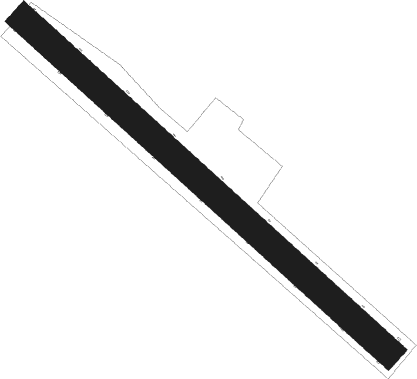
Runway info
Runway 13 / 31
length
769m (2523ft)
bearing
122° / 302°
width
44m (144ft)
surface
grass
Airport layout
Nearby beacons
code
identifier
dist
bearing
frequency
SUW
SUWALKI VOR/DME
18.3
80°
117.70
Disclaimer
The information on this website is not for real aviation. Use this data with the X-Plane flight simulator only! Data taken with kind consent from X-Plane 12 source code and data files. Content is subject to change without notice.