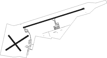
Lublin
Airport details
| Country | Poland |
| State | Lublin Voivodeship |
| Region | EP |
| Airspace | Warsaw Ctr |
| Municipality | Świdnik Duży |
| Elevation | 632ft (193m) |
| Timezone | GMT +1 |
| Coordinates | 51.24028, 22.71361 |
| Magnetic var | |
| Type | land |
| Available since | X-Plane v10.40 |
| ICAO code | EPLB |
| IATA code | n/a |
| FAA code | n/a |
Communication
| Lublin Lublin Tower | 136.425 |
Approach frequencies
| ILS-cat-II | RW25 | 111.95 | 18.00mi |
| 3° GS | RW25 | 111.95 | 18.00mi |
Nearby beacons
| code | identifier | dist | bearing | frequency |
|---|---|---|---|---|
| SWI | SWIDNIK VOR/DME | 1 | 262° | 112.20 |
| IZB | DME | 27.3 | 130° | 117.40 |
| NDE | DEBLIN NDB | 33.2 | 291° | 465 |
| ND | DEBLIN NDB | 34.8 | 291° | 366 |
| TDN | DEBLIN TACAN | 36 | 291° | 108.80 |
| NE | DEBLIN NDB | 37.1 | 291° | 366 |
| NED | DEBLIN NDB | 39.2 | 291° | 465 |
| SIE | SIEDLCE VOR/DME | 58.1 | 331° | 114.70 |
Departure and arrival routes
| Transition altitude | 6500ft |
| SID end points | distance | outbound heading | |
|---|---|---|---|
| RW07 | |||
| USEG1F | 18mi | 187° | |
| LIBG1F | 31mi | 230° | |
| ARGI1F, ARGI1D | 33mi | 248° | |
| VADO1F | 23mi | 275° | |
| RW25 | |||
| USEG1J | 18mi | 187° | |
| LIBG1J | 31mi | 230° | |
| ARGI1J | 33mi | 248° | |
| VADO1J, VADO1R, VADO1U | 23mi | 275° | |
| STAR starting points | distance | inbound heading | |
|---|---|---|---|
| ALL | |||
| OGVE1P | 23.2 | 33° | |
| GAVD1P | 34.1 | 58° | |
| VENE1P | 30.7 | 84° | |
| RW07 | |||
| OGVE1H | 23.2 | 33° | |
| GAVD1H | 34.1 | 58° | |
| VENE1L, VENE1H | 30.7 | 84° | |
| RW25 | |||
| OGVE1G | 23.2 | 33° | |
| GAVD1G | 34.1 | 58° | |
| VENE1G | 30.7 | 84° | |
Instrument approach procedures
| runway | airway (heading) | route (dist, bearing) |
|---|---|---|
| RW07 | LB389 (64°) | LB389 5000ft LB394 (5mi, 340°) 3500ft |
| RNAV | LB394 3500ft LB398 (4mi, 82°) 3000ft EPLB (7mi, 82°) 682ft LB396 (9mi, 82°) 2300ft LB389 (20mi, 252°) 5000ft | |
| RW25 | LB481 (277°) | LB481 3500ft LB483 (4mi, 340°) 2500ft |
| RW25 | LB482 (245°) | LB482 3000ft LB483 (4mi, 160°) 2500ft |
| RNAV | LB483 2500ft LB486 (4mi, 262°) 2000ft EPLB (5mi, 262°) 676ft LB487 (4mi, 262°) LB481 (14mi, 93°) 3500ft |
Holding patterns
| STAR name | hold at | type | turn | heading* | altitude | leg | speed limit |
|---|---|---|---|---|---|---|---|
| GAVD1G | LB479 | VHF | right | 245 (65)° | 5000ft - 6000ft | 1.0min timed | 230 |
| GAVD1H | LB389 | VHF | right | 161 (341)° | 5000ft - 6000ft | 1.0min timed | 230 |
| GAVD1P | SWI | NDB | right | 251 (71)° | 1.0min timed | ICAO rules | |
| OGVE1G | LB479 | VHF | right | 245 (65)° | 5000ft - 6000ft | 1.0min timed | 230 |
| OGVE1H | LB389 | VHF | right | 161 (341)° | 5000ft - 6000ft | 1.0min timed | 230 |
| OGVE1P | SWI | NDB | right | 251 (71)° | 1.0min timed | ICAO rules | |
| VENE1G | LB472 | VHF | right | 243 (63)° | 10000ft - 11000ft | 1.0min timed | 230 |
| VENE1H | LB386 | VHF | right | 260 (80)° | > 10000ft | 1.0min timed | 230 |
| VENE1H | LB389 | VHF | right | 161 (341)° | 5000ft - 6000ft | 1.0min timed | 230 |
| VENE1P | SWI | NDB | right | 251 (71)° | 1.0min timed | ICAO rules | |
| *) magnetic outbound (inbound) holding course | |||||||
Disclaimer
The information on this website is not for real aviation. Use this data with the X-Plane flight simulator only! Data taken with kind consent from X-Plane 12 source code and data files. Content is subject to change without notice.

