Airports for X-Plane offers a convenient way to explore airports and their related communication information for the X-Plane flight simulator. It only uses data from the X-Plane flight simulator itself, and is therefore more reliable than the data that comes from real aviation websites. You can search for airports by using the ICAO code, or browse for airports per country and state. The information displayed is categorized by airport details, runway information, airport communication, approach frequencies (ILS and Glidepath details), details of nearby beacons, SIDs, STARs and approach procedures.

immigration airbus airport authority aircraft corporation air traffic control aerodrome air terminal kennedy takeoff helipad outskirts embassy luggage newark tarmac jet hotel air safety metro

Olsztyn - Olsztyn Dajtki

Airport details

CountryPoland
StateWarmian-Masurian Voivodeship
RegionEP
AirspaceWarsaw Ctr
MunicipalityOlsztyn
Elevation436ft (133m)
TimezoneGMT +1
Coordinates53.77538, 20.41925
Magnetic var
Typeland
Available sinceX-Plane v10.40
ICAO codeEPOD
IATA coden/a
FAA coden/a

Communication

Olsztyn Dajtki Radio122.900
Nearby Points of Interest:
Mendelsohn House
-
Old Town Hall in Olsztyn
-
Cemetery in Olsztyn
-
5 Staszica Street in Olsztyn
-
Willa Bayer w Olsztynie
-
High Gate in Olsztyn
-
Olsztyn Town Hall
-
Tartak Raphaelsohnów in Olsztyn
-
Willa Secesyjna w Olsztynie
-
1 Emilii Plater Street in Olsztyn
-
Kamienica Jurckschata
-
Budynek szkoły polskiej w Unieszewie
-
Kościół Znalezienia Krzyża Św. w Klebarku Wielkim
-
Lutheran church in Łęguty
-
Synagogue in Barczewo
-
Town hall in Barczewo
-
Protestant Church in Barczewo
-
Church of St. Anne and St. Stefan in Barczewo
-
Mury miejskie w Barczewie
-
Barczewo Castle
-
Old Church in Olsztynek
-
Olsztynek town hall
-
Water tower in Dobre Miasto
-
Saint James the Greater church in Bartołty Wielkie
-
Palace in Smolajny

Runway info

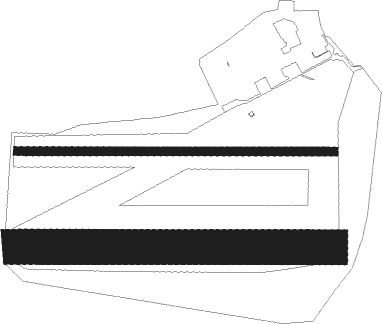
Runway 09L / 27R  
 length851m (2792ft)
 bearing93° / 273°
 width23m (75ft)
 surfaceasphalt
 displ threshold300m (984ft) / 0m (0ft)
Runway 09R / 27L  
 length842m (2762ft)
 bearing93° / 273°
 width93m (304ft)
 surfacegrass
 displ threshold256m (840ft) / 110m (361ft)

Airport layout


Parking locations

Nearby beacons

codeidentifierdistbearingfrequency
OSYDME5.7260°116.25
SYNSZYMANY VOR/DME23.2106°111.05
MRAMRAGOWO VOR/DME25.389°117.30
DIADME49.7133°117.95

Disclaimer

The information on this website is not for real aviation. Use this data with the X-Plane flight simulator only! Data taken with kind consent from X-Plane 12 source code and data files. Content is subject to change without notice.