Gdynia - Oksywie
Airport details
| Country | Poland |
| State | Pomeranian Voivodeship |
| Region | EP |
| Airspace | Warsaw Ctr |
| Municipality | gmina Kosakowo |
| Elevation | 146ft (45m) |
| Timezone | GMT +1 |
| Coordinates | 54.58571, 18.52799 |
| Magnetic var | |
| Type | land |
| Available since | X-Plane v10.40 |
| ICAO code | EPOK |
| IATA code | QYD |
| FAA code | n/a |
Communication
| Oksywie OKSYWIE TOWER | 119.850 |
| Oksywie OKSYWIE ApproachROACH | 134.000 |
Approach frequencies
| ILS-cat-I | RW31 | 109.5 | 18.00mi |
| 3° GS | RW31 | 109.5 | 18.00mi |
Nearby Points of Interest:
Morska 83 in Gdynia
-67 Morska Street in Gdynia
-25 Jana z Kolna Street in Gdynia
-Courthouse in Gdynia
-10a Starowiejska Street in Gdynia
-7 Starowiejska Street in Gdynia
-Gmach Biura Budowy Portu
-Insurance and Polish Ocean Lines building in Gdynia
-16 Kościuszki Square in Gdynia
-Pręczkowski Building in Gdynia
-Parish of the Sacred Heart of Lord Jesus in Gdynia
-9 Słupecka Street in Gdynia, Poland
-3rd Aleja Jana Pawła II in Gdynia
-68 Świętojańska Street in Gdynia
-Villa Orla in Gdynia
-55 Świętojańska Street in Gdynia
-Villa Poznanianka in Gdynia
-Villa Otok in Gdynia
-Villa Zosieńka in Gdynia
-Villa Szczęść Boże in Gdynia
-Villa Szumka in Gdynia
-1a Sieroszewskiego Street in Gdynia
-Villa Sokola in Gdynia
-Villa Sadyba in Gdynia
-Willa Bliźniacza in Gdynia
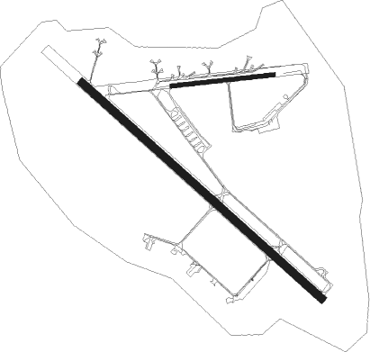
Runway info
Runway 08 / 26  | ||
| length | 791m (2595ft) | |
| bearing | 89° / 269° | |
| width | 30m (98ft) | |
| surface | asphalt | |
| Runway 13 / 31 | ||
| length | 2498m (8196ft) | |
| bearing | 121° / 301° | |
| width | 60m (197ft) | |
| surface | concrete | |
| blast zone | 255m (837ft) / 0m (0ft) | |
Nearby beacons
| code | identifier | dist | bearing | frequency |
|---|---|---|---|---|
| TOW | OKSYWIE (GDYNIA) TACAN | 0.7 | 261° | 113.50 |
| NO | OKSYWIE (GDYNIA) NDB | 1.3 | 285° | 290 |
| NW | OKSYWIE (GDYNIA) NDB | 1.4 | 146° | 290 |
| NWO | OKSYWIE (GDYNIA) NDB | 2.6 | 134° | 494 |
| NOW | OKSYWIE (GDYNIA) NDB | 3 | 293° | 494 |
| GZD | GDANSK VOR/DME | 12.4 | 207° | 116.10 |
| NE | PRUSZCZ GDANSKI NDB | 21.3 | 153° | 300 |
| NET | PRUSZCZ GDANSKI NDB | 22 | 148° | 370 |
| ML | CEWICE NDB | 25.7 | 257° | 311 |
| M | CEWICE NDB | 27.3 | 257° | 423 |
| TCW | CEWICE TACAN | 28.5 | 257° | 113.95 |
| WIC | DME | 30.1 | 276° | 108 |
| KMI | DME | 31.5 | 122° | 116.80 |
| TMB | MALBORK TACAN | 39.8 | 133° | 117.10 |
| NB | MALBORK NDB | 40.2 | 131° | 345 |
Disclaimer
The information on this website is not for real aviation. Use this data with the X-Plane flight simulator only! Data taken with kind consent from X-Plane 12 source code and data files. Content is subject to change without notice.