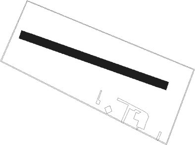
Airports for X-Plane offers a convenient way to explore airports and their related communication information for the X-Plane flight simulator. It only uses data from the X-Plane flight simulator itself, and is therefore more reliable than the data that comes from real aviation websites. You can search for airports by using the ICAO code, or browse for airports per country and state. The information displayed is categorized by airport details, runway information, airport communication, approach frequencies (ILS and Glidepath details), details of nearby beacons, SIDs, STARs and approach procedures.

faa hotel gravel nearby customs consulate landing arriving train helipad capital government flown airbase seaplane runway lighting embassy jetliner airport terminal airplane

Ostrów Wielkopolski - Michalkow Airfield

Airport details

CountryPoland
StateGreater Poland Voivodeship
RegionEP
AirspaceWarsaw Ctr
Municipalitygmina Ostrów Wielkopolski
Elevation469ft (143m)
TimezoneGMT +1
Coordinates51.70248, 17.84681
Magnetic var
Typeland
Available sinceX-Plane v10.40
ICAO codeEPOM
IATA coden/a
FAA coden/a

Communication

No airport communication available for EPOM
Nearby Points of Interest:
Kościół św. Mateusza Apostoła w Górznie
-
New Synagogue, Ostrów Wielkopolski
-
Saint John the Baptist church in Ołobok
-
Water mill in Ołobok
-
36 Śródmiejska Street in Kalisz
-
4 Mostowa Street in Kalisz
-
Courthouse in Kalisz
-
Kalisz Town Hall
-
Saint Barbara church in Karmin
-
Kościół poewangelicki w Odolanowie
-
Kościół św. Rocha w Mikstacie
-
Pleszew town hall
-
Kościół św. Jakuba w Tłokini Kościelnej
-
Kościół poewangelicki w Dobrzycy
-
Saint Stanislaus Kostka church in Brudzew
-
Kościół św. Jakuba Apostoła w Czerminie
-
Krotoszyn Town Hall
-
Kościół poewangelicki w Grabowie nad Prosną
-
Manor in Wziąchowo Wielkie
-
Evangelical church in Stawiszyn
-
Kościół św. Barbary w Magnuszewicach
-
Kościół Najświętszej Maryi Panny Niepokalanie Poczętej w Goliszewie
-
Klasztor Franciszkanów w Choczu
-
Palace in Wziąchowo Małe
-
Ostrzeszów Town Hall

Runway info

Runway 11 / 29
 length952m (3123ft)
 bearing105° / 285°
 width52m (171ft)
 surfacegrass

Airport layout


Parking locations

Nearby beacons

codeidentifierdistbearingfrequency
TBNGORNY DME37239°113.60
NGPOWIDZ NDB40.1322
NTPOWIDZ NDB40.4303
TPWPOWIDZ TACAN40.5115.55
NKKRZESINY (POZNAN) NDB48.7306°489
TKSKRZESINY (POZNAN) TACAN49.9306°111.50
WCLWROCLAW VOR/DME50.4237°111.65
WIEDME54.9142°109.65

Disclaimer

The information on this website is not for real aviation. Use this data with the X-Plane flight simulator only! Data taken with kind consent from X-Plane 12 source code and data files. Content is subject to change without notice.