Airports for X-Plane offers a convenient way to explore airports and their related communication information for the X-Plane flight simulator. It only uses data from the X-Plane flight simulator itself, and is therefore more reliable than the data that comes from real aviation websites. You can search for airports by using the ICAO code, or browse for airports per country and state. The information displayed is categorized by airport details, runway information, airport communication, approach frequencies (ILS and Glidepath details), details of nearby beacons, SIDs, STARs and approach procedures.

passengers passenger airport terminal international airport taxiway plane air safety frankfurt airport nation control tower airspeed airdock non-towered airport airspace customs aircraft carrier near road automated airport weather station rail transport

Piła - Pila

Airport details

CountryPoland
StateGreater Poland Voivodeship
RegionEP
AirspaceWarsaw Ctr
MunicipalityPila
Elevation270ft (82m)
TimezoneGMT +1
Coordinates53.16972, 16.71056
Magnetic var
Typeland
Available sinceX-Plane v10.40
ICAO codeEPPI
IATA coden/a
FAA coden/a

Communication

No airport communication available for EPPI
Nearby Points of Interest:
Okrąglak roundhouse in Piła
-
Kościół poewangelicki w Ujściu
-
Ratusz w Ujściu
-
Church of the Transfiguration in Morzewo
-
Church of St. John in Głubczyn
-
Town hall in Wałcz
-
36a Żeromskiego Street in Trzcianka
-
St. Jacob the Apostle Church in Bługowo
-
Kościół Narodzenia Najświętszej Maryi Panny w Karsiborze
-
Czarnków Town Hall
-
Church in Wyszyny
-
Church of the Visitation in Strzaliny
-
Kościół Wniebowzięcia Najświętszej Maryi Panny w Lipiej Górze
-
Saint Catherine of Alexandria church in Marcinkowice
-
Kościół św. Jakuba Apostoła w Bronikowie
-
Saint Anne church in Jaktorowo
-
Protestant church in Ryczywół
-
Our Lady of the Rosary church in Martew
-
St. Andrew's Church in Boruszyn
-
Church of the Ascension of Christ in Łomczewo

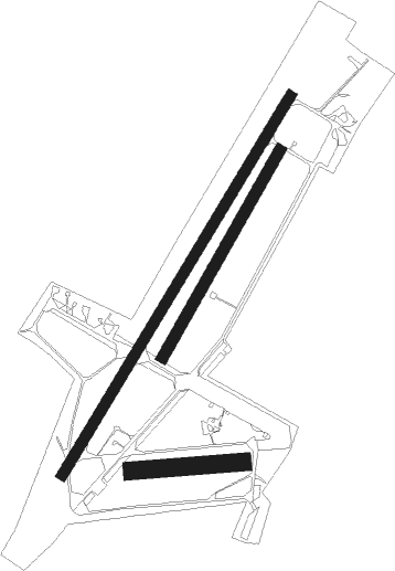
Runway info

Runway 03 / 21  
 length2425m (7956ft)
 bearing50° / 230°
 width59m (194ft)
 surfaceconcrete
Runway 03R / 21L  
 length1301m (4268ft)
 bearing48° / 228°
 width60m (197ft)
 surfacegrass
Runway 09 / 27  
 length608m (1995ft)
 bearing90° / 270°
 width98m (320ft)
 surfacegrass

Airport layout


Nearby beacons

codeidentifierdistbearingfrequency
CZADME25310°117
NAMIROSLAWIEC NDB25.1290°297
TMIMIROSLAWIEC TACAN26.8290°115.35
DREDME38.1248°115.30
LAWLAWICA (POZNAN) VOR/DME45171°115.80
NDSWIDWIN NDB47.8306°280
TSNSWIDWIN TACAN47.9306°116
TKSKRZESINY (POZNAN) TACAN51163°111.50
NKKRZESINY (POZNAN) NDB51.9161°489

Disclaimer

The information on this website is not for real aviation. Use this data with the X-Plane flight simulator only! Data taken with kind consent from X-Plane 12 source code and data files. Content is subject to change without notice.