Airports for X-Plane offers a convenient way to explore airports and their related communication information for the X-Plane flight simulator. It only uses data from the X-Plane flight simulator itself, and is therefore more reliable than the data that comes from real aviation websites. You can search for airports by using the ICAO code, or browse for airports per country and state. The information displayed is categorized by airport details, runway information, airport communication, approach frequencies (ILS and Glidepath details), details of nearby beacons, SIDs, STARs and approach procedures.

immigration airdrome airspace control tower international airport non-towered airport pilot city hangar aircraft carrier rail newark airliner airfield traffic pattern grass customs traffic arrival passengers flight attendant

Przasnysz

Airport details

CountryPoland
StateMasovian Voivodeship
RegionEP
AirspaceWarsaw Ctr
Municipalitygmina Przasnysz
Elevation382ft (116m)
TimezoneGMT +1
Coordinates53.00994, 20.93328
Magnetic var
Typeland
Available sinceX-Plane v10.40
ICAO codeEPPZ
IATA coden/a
FAA coden/a

Communication

Przasnysz Przasnysz-Radio122.600
Nearby Points of Interest:
Town Hall in Przasnysz
-
Saint Stanislaus church in Płoniawy-Bramura
-
Kościół Podwyższenia Krzyża Świętego w Krasnem
-
Church of Saint Achatius and the Companions of Martyrs in Czernice Borowe
-
Corpus Christi church in Maków Mazowiecki
-
Ciechanów Townhall
-
Manor in Koźniewo Wielkie
-
Kościół św. Stanisława w Sieluniu
-
Saint Joseph church in Pułtusk
-
Saints Peter and Paul church in Pułtusk
-
Pułtusk Castle
-
Mława Town Hall
-
City park in Mława
-
Immaculate Conception church in Czarnia
-
Mauzoleum bitwy pod Ostrołęką
-
Kościół Świętego Ducha w Kadzidle
-
Kościół Podwyższenia Krzyża Świętego w Goworowie
-
Holy Trinity church in Nowe Miasto

Runway info

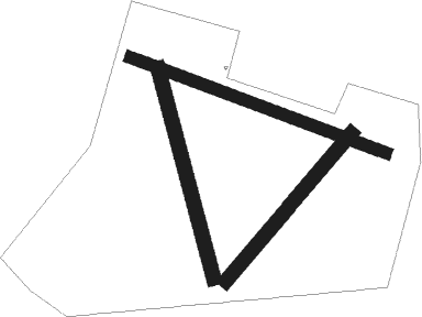
Runway 05 / 23  
 length816m (2677ft)
 bearing59° / 239°
 width60m (197ft)
 surfacegrass
Runway 17 / 35  
 length913m (2995ft)
 bearing163° / 343°
 width60m (197ft)
 surfacegrass
Runway 11L / 29R  
 length1147m (3763ft)
 bearing106° / 286°
 width50m (164ft)
 surfacegrass

Airport layout


Nearby beacons

codeidentifierdistbearingfrequency
DIADME9.674°117.95
MOLMODLIN VOR/DME34.7205°116.60
SYNSZYMANY VOR/DME35.9111.05
WARZABOROWEK VOR/DME46.1200°114.90
MRAMRAGOWO VOR/DME4714°117.30
OSYDME50.3318°116.25
OKCOKECIE (WARSAW) VOR/DME50.4178°113.45
TMMMINSK MAZOWIECKI TACAN55.7138°117.05
NFMINSK MAZOWIECKI NDB56.2137°282

Disclaimer

The information on this website is not for real aviation. Use this data with the X-Plane flight simulator only! Data taken with kind consent from X-Plane 12 source code and data files. Content is subject to change without notice.