Airports for X-Plane offers a convenient way to explore airports and their related communication information for the X-Plane flight simulator. It only uses data from the X-Plane flight simulator itself, and is therefore more reliable than the data that comes from real aviation websites. You can search for airports by using the ICAO code, or browse for airports per country and state. The information displayed is categorized by airport details, runway information, airport communication, approach frequencies (ILS and Glidepath details), details of nearby beacons, SIDs, STARs and approach procedures.

buildings downtown arriving airborne flights customs government port aviation concrete heliport railway station non-towered airport newark luggage air traffic control faa airport apron passenger stolport

Czerwonka-parcel - Sochaczew

Airport details

CountryPoland
StateMasovian Voivodeship
Region
AirspaceWarsaw Ctr
MunicipalityKaźmierów
Elevation290ft (88m)
TimezoneGMT +1
Coordinates52.20184, 20.27368
Magnetic var
Typeland
Available sinceX-Plane v10.40
ICAO codeEPSO
IATA coden/a
FAA coden/a

Communication

No airport communication available for EPSO
Nearby Points of Interest:
Palace in Teresin
-
Kościół św. Bartłomieja Apostoła w Rybnie
-
Kościół św. Rocha i św. Jana Chrzciciela w Brochowie
-
Kaplica grobowa Łubieńskich w Wiskitkach
-
Cmentarz wojenny w Wiskitkach
-
All Saints church in Wiskitki
-
Jewish cemetery in Bolimów
-
Joachimów-Mogiły German military cemetery
-
Zespół dworski
-
Jewish Cemetery, Żyrardów
-
Our Lady of the Angels church in Wyszogród
-
Holy Trinity church in Wyszogród
-
Łuszczewski Palace in Leszno
-
Kościół Narodzenia św. Jana Chrzciciela w Lesznie
-
Błonie town hall
-
Town hall in Łowicz
-
Evangelical-Augsburg church in Łowicz
-
Kościół św. Michała Archanioła w Puszczy Mariańskiej
-
Pedagogical College in Łowicz
-
Cemetery in Żuków
-
Church of the Transfiguration in Żuków
-
Saint Anne church in Grodzisk Mazowiecki
-
Villa Waleria in Milanówek
-
Willa Dalmacja

Runway info

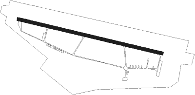
Runway 11 / 29
 length2487m (8159ft)
 bearing101° / 281°
 width59m (193ft)
 surfaceasphalt
 displ threshold436m (1430ft) / 199m (653ft)

Airport layout


Nearby beacons

codeidentifierdistbearingfrequency
WARZABOROWEK VOR/DME14.581°114.90
KRNDME16.5146°117.80
MOLMODLIN VOR/DME21.158°116.60
OKCOKECIE (WARSAW) VOR/DME25.393°113.45
LOZWIACZYN DOLNY VOR/DME35237°112.40
LINDME36.4107°113.10
TTMTOMASZOW MAZOWIECKI TACAN37.4196°110.70
NPTOMASZOW MAZOWIECKI NDB37.9193°437
NPRTOMASZOW MAZOWIECKI NDB38.4190°488
PCKDME40306°117.65
NRRADOM NDB60.3130°313
DIADME62.146°117.95

Disclaimer

The information on this website is not for real aviation. Use this data with the X-Plane flight simulator only! Data taken with kind consent from X-Plane 12 source code and data files. Content is subject to change without notice.