Stalowa Wola - Turbia
Airport details
| Country | Poland |
| State | Subcarpathian Voivodeship |
| Region | EP |
| Airspace | Warsaw Ctr |
| Municipality | Turbia |
| Elevation | 492ft (150m) |
| Timezone | GMT +1 |
| Coordinates | 50.62751, 21.99815 |
| Magnetic var | |
| Type | land |
| Available since | X-Plane v10.40 |
| ICAO code | EPST |
| IATA code | n/a |
| FAA code | n/a |
Communication
| Turbia TURBIA RADIO | 122.205 |
Nearby Points of Interest:
Cemetery in Racławice, Subcarpathian voivodeship
-Cmentarz kościelny w Racławicach
-Sandomierz Town Hall
-Sandomierz Synagogue
-Church of St. Joseph in Sandomierz
-Cathedral Cemetery in Sandomierz
-Kościół rektoralny Św. Jana Chrzciciela w Zawichoście
-Our Lady of Sorrows church in Jarocin
-Holy Trinity church in Zawichost
-Kościół św. Mikołaja w Potoku Wielkim
-Na Piaskach cemetery in Tarnobrzeg
-Kaplica Archanioła Gabriela w Tarnobrzegu
-Jewish cemetery in Ulanów
-Holy Trinity church in Samborzec
-Saint Onuphrius and Immaculate Heart of Mary church in Dąbrówka
-Wooden Saints Joachim and Anne church in Annopol
-Building in the Cistercian Abbey in Koprzywnica
-Saint Florian church in Koprzywnica
-Church of St. John the Baptist in Janów Lubelski
-New Jewish cemetery in Annopol
-Cmentarz wojenny w Bukowinie
-World War I Cemetery in Janów Lubelski
-Saint Anne church in Janików
-Jewish Cemetery in Majdan Królewski
-Cmentarz w Hucie Krzeszowskiej
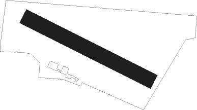
Runway info
| Runway 12 / 30 | ||
| length | 873m (2864ft) | |
| bearing | 111° / 291° | |
| width | 100m (328ft) | |
| surface | grass | |
Nearby beacons
| code | identifier | dist | bearing | frequency |
|---|---|---|---|---|
| RSW | LUKAWIEC VOR/DME | 31.5 | 165° | 110.60 |
| SWI | SWIDNIK VOR/DME | 44.8 | 48° | 112.20 |
| NRA | RADOM NDB | 53.7 | 317° | 328 |
| NDE | DEBLIN NDB | 54 | 357° | 465 |
| NR | RADOM NDB | 54.1 | 315° | 313 |
| ND | DEBLIN NDB | 54.9 | 355° | 366 |
| TDN | DEBLIN TACAN | 55.7 | 354° | 108.80 |
| NE | DEBLIN NDB | 56.2 | 352° | 366 |
| NED | DEBLIN NDB | 57.5 | 349° | 465 |
Disclaimer
The information on this website is not for real aviation. Use this data with the X-Plane flight simulator only! Data taken with kind consent from X-Plane 12 source code and data files. Content is subject to change without notice.