Tomaszów Mazowiecki - Tomaszow Mazowiecki
Airport details
| Country | Poland |
| State | Łódź Voivodeship |
| Region | EP |
| Airspace | Warsaw Ctr |
| Municipality | gmina Lubochnia |
| Elevation | 603ft (184m) |
| Timezone | GMT +1 |
| Coordinates | 51.58445, 20.09722 |
| Magnetic var | |
| Type | land |
| Available since | X-Plane v10.40 |
| ICAO code | EPTM |
| IATA code | n/a |
| FAA code | n/a |
Communication
Nearby Points of Interest:
Kościół św. Marcina w Tomaszowie Mazowieckim (stary)
-Saint Margaret of Antioch church in Czerniewice
-Saint Joseph church in Studzianna
-Saint Anne chapel in Studzianna
-Rawa Mazowiecka Town Hall
-Church of the Assumption in Rawa Mazowiecka
-Saint Mary Magdalene church in Opoczno
-Opoczno Castle
-Saint Florian church in Sulejów
-Saint Roch church in Łęgonice
-Kościół św. Kazimierza i klasztor kapucynów w Nowym Mieście nad Pilicą
-Orthodox cemetery in Piotrków Trybunalski
-Jüttner family chapel in Piotrków Trybunalski
-Kaplica grobowa T. Andriejewej
-Burghard family chapel in Piotrków Trybunalski
-8 Farna Street in Piotrków Trybunalski
-3 Farna Street in Piotrków Trybunalski
-6 Grodzka Street in Piotrków Trybunalski
-kamienica przy Placu Czarnieckiego 10
-Piarist monastery in Piotrków Trybunalski
-6 Rwańska Street in Piotrków Trybunalski
-10 Trybunalski Market Square in Piotrków Trybunalski
-Former girls' school in Piotrków Trybunalski
-Dominican nuns convent in Piotrków Trybunalski
-6 Sieradzka Street in Piotrków Trybunalski
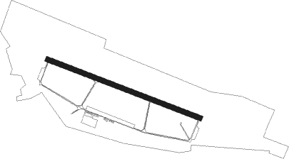
Runway info
| Runway 11 / 29 | ||
| length | 1994m (6542ft) | |
| bearing | 107° / 287° | |
| width | 60m (197ft) | |
| surface | asphalt | |
Nearby beacons
| code | identifier | dist | bearing | frequency |
|---|---|---|---|---|
| TTM | TOMASZOW MAZOWIECKI TACAN | 0.2 | 310° | 110.70 |
| NP | TOMASZOW MAZOWIECKI NDB | 1.1 | 106° | 437 |
| NPR | TOMASZOW MAZOWIECKI NDB | 2.6 | 107° | 488 |
| LOZ | WIACZYN DOLNY VOR/DME | 21 | 292° | 112.40 |
| KRN | DME | 25.2 | 44° | 117.80 |
| TAS | LASK TACAN | 34.3 | 268° | 108.55 |
| NWT | LECZYCA NDB | 40.7 | 295° | 385 |
| NW | LECZYCA NDB | 42.2 | 294° | 520 |
| TLY | LECZYCA TACAN | 43.3 | 294° | 110.10 |
| WAR | ZABOROWEK VOR/DME | 45.5 | 40° | 114.90 |
| OKC | OKECIE (WARSAW) VOR/DME | 47.5 | 56° | 113.45 |
| MOL | MODLIN VOR/DME | 56.3 | 34° | 116.60 |
| JED | DME | 56.5 | 171° | 115.60 |
Disclaimer
The information on this website is not for real aviation. Use this data with the X-Plane flight simulator only! Data taken with kind consent from X-Plane 12 source code and data files. Content is subject to change without notice.