Airports for X-Plane offers a convenient way to explore airports and their related communication information for the X-Plane flight simulator. It only uses data from the X-Plane flight simulator itself, and is therefore more reliable than the data that comes from real aviation websites. You can search for airports by using the ICAO code, or browse for airports per country and state. The information displayed is categorized by airport details, runway information, airport communication, approach frequencies (ILS and Glidepath details), details of nearby beacons, SIDs, STARs and approach procedures.

propeller plane station airborne corporation airdock nearby metro field drome southwest international control tower landing arrival buildings airline tarmac aviation near downtown

Włocławek - Wloclawek Kruszyn

Airport details

CountryPoland
StateKuyavian-Pomeranian Voivodeship
RegionEP
AirspaceWarsaw Ctr
MunicipalityKruszyn
Elevation214ft (65m)
TimezoneGMT +1
Coordinates52.58462, 19.01550
Magnetic var
Typeland
Available sinceX-Plane v10.40
ICAO codeEPWK
IATA coden/a
FAA coden/a

Communication

Wloclawek Kruszyn Kruszyn RADIO122.400
Nearby Points of Interest:
Saint Stanislaus church in Brześć Kujawski
-
Brześć Kujawski Town Hall
-
Kościół św. Michała Archanioła w Brześciu Kujawskim
-
12 Kościuszki Street in Włocławek
-
Saint John the Baptist church in Włocławek
-
Bishops Palace in Włocławek
-
Manor in Borucinek
-
Manor in Kłóbka
-
Saint Matthew church in Bądkowo
-
Church of the Pokrov in Osięciny
-
Bobrowniki castle
-
Kościół św. Doroty w Orlem
-
Kościół świętych Stanisława i Marii Magdaleny w Przypuście
-
Kościół Znalezienia Krzyża Świętego w Nieszawie
-
Nieszawa town hall
-
Przedecz Town Hall
-
Kościół św. Piotra i Pawła w Rokiciu
-
Kościół Matki Boskiej Częstochowskiej w Mąkoszynie
-
Palace in Nowy Duninów
-
Kościół św. Józefa w Zakrzewie
-
Raciążek Castle
-
Kościół św. Wawrzyńca w Lubotyniu
-
Saint Martin church in Straszewo
-
Saint James church in Piotrków Kujawski
-
Kościół św. Dominika w Bierzwiennej Długiej

Runway info

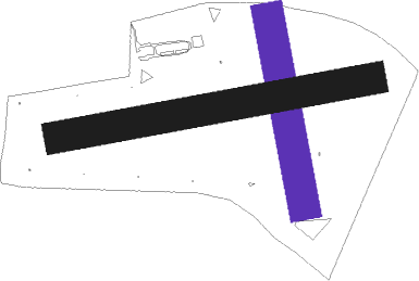
Runway 17 / 35
 length601m (1972ft)
 bearing170° / 350°
 width100m (328ft)
 surfacegrass
Runway 08 / 26  
 length1001m (3284ft)
 bearing86° / 266°
 width100m (328ft)
 surfacegrass

Airport layout - runway 17 / 35


Nearby beacons

codeidentifierdistbearingfrequency
PCKDME21.577°117.65
NRDINOWROCLAW NDB28.3292°444
NRINOWROCLAW NDB28.6290°262
TIRINOWROCLAW TACAN28.9289°109.25
TLYLECZYCA TACAN35.3168°110.10
NWLECZYCA NDB35.6164°520
NWTLECZYCA NDB36.3161°385
LOZWIACZYN DOLNY VOR/DME53.4143°112.40
GRUGRUDZIADZ VOR/DME56.8346°114.60

Disclaimer

The information on this website is not for real aviation. Use this data with the X-Plane flight simulator only! Data taken with kind consent from X-Plane 12 source code and data files. Content is subject to change without notice.