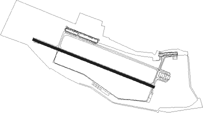
Wrocław - Wroclaw Strachowice
Airport details
| Country | Poland |
| State | Lower Silesian Voivodeship |
| Region | EP |
| Airspace | Warsaw Ctr |
| Municipality | Wrocław |
| Elevation | 403ft (123m) |
| Timezone | GMT +1 |
| Coordinates | 51.10299, 16.89844 |
| Magnetic var | |
| Type | land |
| Available since | X-Plane v10.40 |
| ICAO code | EPWR |
| IATA code | WRO |
| FAA code | n/a |
Communication
| Wroclaw Strachowice ATIS | 124.330 |
| Wroclaw Strachowice Wroclaw DELIVERY | 121.805 |
| Wroclaw Strachowice Wroclaw TOWER | 120.255 |
| Wroclaw Strachowice Poznan ApproachROACH | 127.230 |
| Wroclaw Strachowice Poznan ApproachROACH | 128.925 |
| Wroclaw Strachowice Wroclaw DepartureARTURE | 120.255 |
Approach frequencies
| ILS-cat-II | RW29 | 110.3 | 18.00mi |
| 3° GS | RW29 | 110.3 | 18.00mi |
Nearby Points of Interest:
Wrocław – Copernicus Airport
-Zamek w Smolcu
-Leśnica Castle
-Port lotniczy Gądów Mały
-Palace in Małkowice
-Pałac w Gałowie
-House of the Golden Dog
-Brandenburg Station in Wrocław
-Dwór w Bielanach Wrocławskich
-St. Andrew the Apostle Church in Bielany Wrocławskie
-40 Świętego Mikołaja Street, Wrocław
-Jewish community building in Wrocław
-Ballestrem Palace in Wrocław
-Wrocław, Szpital Bożego Grobu
-Wrocław University Library
-4 Solny Square, Wrocław
-Rybisch House, Wrocław
-Pałac w Jarząbkowicach
-Renoma
-60 Market Square in Wrocław
-59 Market Square in Wrocław
-Wrocław New Town Hall
-Landeshaus, Wrocław
-56 Market Square in Wrocław
-55 Market Square in Wrocław
Nearby beacons
| code | identifier | dist | bearing | frequency |
|---|---|---|---|---|
| WCL | WROCLAW VOR/DME | 0.9 | 117° | 111.65 |
| TBN | GORNY DME | 13.5 | 54° | 113.60 |
Departure and arrival routes
| Transition altitude | 6500ft |
| SID end points | distance | outbound heading | |
|---|---|---|---|
| RW11 | |||
| XIDN1A | 36mi | 9° | |
| LUNU1A | 48mi | 73° | |
| MAPI1A | 62mi | 113° | |
| PEKO1A | 48mi | 143° | |
| ULGI2A | 33mi | 270° | |
| RW29 | |||
| XIDN1K | 36mi | 9° | |
| LUNU1K | 48mi | 73° | |
| MAPI1K | 62mi | 113° | |
| PEKO1K | 48mi | 143° | |
| ULGI1K | 33mi | 270° | |
| STAR starting points | distance | inbound heading | |
|---|---|---|---|
| RW11 | |||
| DINO3P | 32.4 | 78° | |
| VAGN1P | 35.3 | 98° | |
| XIDN1P | 36.0 | 189° | |
| UVIV1P | 47.0 | 244° | |
| SUDO1P | 63.3 | 287° | |
| EPOP1P | 55.8 | 309° | |
| RW29 | |||
| DINO1U | 32.4 | 78° | |
| VAGN1U | 35.3 | 98° | |
| XIDN1U | 36.0 | 189° | |
| UVIV1U | 47.0 | 244° | |
| SUDO1U | 63.3 | 287° | |
| EPOP1U | 55.8 | 309° | |
Instrument approach procedures
| runway | airway (heading) | route (dist, bearing) |
|---|---|---|
| RW11 | WR604 (106°) | WR604 4500ft WR603 (5mi, 107°) 3000ft WR602 (5mi, 107°) 1700ft |
| RNAV | WR602 1700ft WR601 (1mi, 107°) 1700ft EPWR (5mi, 105°) 454ft WR653 (16mi, 108°) 3000ft | |
| RW29 | WR704 (288°) | WR704 5000ft WR703 (5mi, 287°) 4000ft WR702 (4mi, 287°) 2700ft |
| RNAV | WR702 2700ft WR701 (1mi, 287°) 2700ft EPWR (7mi, 288°) 451ft WR762 (17mi, 286°) 3000ft |
Holding patterns
| STAR name | hold at | type | turn | heading* | altitude | leg | speed limit |
|---|---|---|---|---|---|---|---|
| DINO1U | WR743 | VHF | right | 264 (84)° | 1.5min timed | 230 | |
| DINO3P | DINOV | VHF | left | 263 (83)° | 1.0min timed | 230 | |
| EPOP1P | WR636 | VHF | right | 137 (317)° | 1.0min timed | 230 | |
| EPOP1U | WR732 | VHF | right | 146 (326)° | 1.5min timed | 230 | |
| SUDO1P | APTAS | VHF | right | 116 (296)° | 1.0min timed | 230 | |
| SUDO1U | WR722 | VHF | right | 111 (291)° | 1.0min timed | 230 | |
| UVIV1P | WR612 | VHF | right | 68 (248)° | 1.0min timed | 230 | |
| UVIV1U | WR711 | VHF | left | 19 (199)° | 1.0min timed | 230 | |
| VAGN1P | VAGNI | VHF | left | 285 (105)° | 1.5min timed | 230 | |
| VAGN1U | WR754 | VHF | left | 288 (108)° | 1.5min timed | 230 | |
| XIDN1P | WR609 | VHF | right | 20 (200)° | 1.0min timed | 230 | |
| XIDN1U | WR707 | VHF | left | 336 (156)° | 1.5min timed | 230 | |
| *) magnetic outbound (inbound) holding course | |||||||
Disclaimer
The information on this website is not for real aviation. Use this data with the X-Plane flight simulator only! Data taken with kind consent from X-Plane 12 source code and data files. Content is subject to change without notice.