Airports for X-Plane offers a convenient way to explore airports and their related communication information for the X-Plane flight simulator. It only uses data from the X-Plane flight simulator itself, and is therefore more reliable than the data that comes from real aviation websites. You can search for airports by using the ICAO code, or browse for airports per country and state. The information displayed is categorized by airport details, runway information, airport communication, approach frequencies (ILS and Glidepath details), details of nearby beacons, SIDs, STARs and approach procedures.

automated airport weather station landing commuter port stol railway station heliport flight attendant runway lighting city government control tower airdock public transport hangar gravel air safety arriving traffic asphalt

Norrköping - Bråvalla

Airport details

CountrySweden
StateÖstergötlands län
Region
AirspaceSweden Ctr
MunicipalityNorrköpings kommun
Elevation88ft (27m)
TimezoneGMT +1
Coordinates58.61945, 16.09323
Magnetic var
Typeland
Available sinceX-Plane v10.40
ICAO codeESCK
IATA coden/a
FAA coden/a

Communication

No airport communication available for ESCK
Nearby Points of Interest:
Östergötlands runinskrifter Fv1959;241
-
Östergötlands runinskrifter Fv1959;243
-
Östergötlands runinskrifter 47
-
Östergötlands runinskrifter 46
-
Östergötlands runinskrifter 48
-
Torsklint
-
Kvillinge socken
-
Östergötlands runinskrifter KJ54
-
Östergötland Runic Inscription 43
-
Himmelstalunds herrgård
-
Marieborgs herrgård
-
Svärtinge kyrka
-
Klockargården Church
-
Villa Norrköping
-
Domaresten
-
Anstalten Norrköping
-
Bergslagsgården
-
Gamla stadshuset, Norrköping
-
Strykjärnet
-
W6-huset
-
Norrköping Town
-
Norrköpings rådhus
-
Stenhuset på Saltängen
-
Swartziska huset
-
Sockerbruket Gripen

Runway info

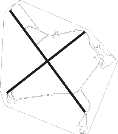
Runway 15 / 33  
 length2246m (7369ft)
 bearing130° / 310°
 width38m (125ft)
 surfaceasphalt
 blast zone15m (49ft) / 50m (164ft)
Runway 06 / 24  
 length1754m (5755ft)
 bearing71° / 251°
 width38m (125ft)
 surfaceasphalt
 blast zone15m (49ft) / 15m (49ft)

Airport layout


Nearby beacons

codeidentifierdistbearingfrequency
ONNORRKOPING NDB9.297°324
OLSAAB (LINKOPING) NDB17230°415
SCSAAB (LINKOPING) NDB20.3251°300
VSNVASSEN VOR/DME22.4230°115.25
NWSKAVSTA (STOCKHOLM) NDB23.576°364
LCFMALMEN (LINKOPING) NDB26.3244°285
PEOSKAVSTA (STOCKHOLM) NDB31.579°398
LXESKILSTUNA NDB43.843°402
RDVAESTERAAS AB (STOCKHOLM) NDB56.130°419
ARSAROS VOR/DME60.530°112.80

Disclaimer

The information on this website is not for real aviation. Use this data with the X-Plane flight simulator only! Data taken with kind consent from X-Plane 12 source code and data files. Content is subject to change without notice.