Airports for X-Plane offers a convenient way to explore airports and their related communication information for the X-Plane flight simulator. It only uses data from the X-Plane flight simulator itself, and is therefore more reliable than the data that comes from real aviation websites. You can search for airports by using the ICAO code, or browse for airports per country and state. The information displayed is categorized by airport details, runway information, airport communication, approach frequencies (ILS and Glidepath details), details of nearby beacons, SIDs, STARs and approach procedures.

buildings airspeed customs immigration southwest air terminal city station taxiway seaplane runway lighting military metro luggage airfield consulate corporation flight asphalt stopover

Eslöv

Airport details

CountrySweden
StateSkåne län
RegionES
AirspaceSweden Ctr
MunicipalityEslövs kommun
Elevation195ft (59m)
TimezoneGMT +1
Coordinates55.84833, 13.33111
Magnetic var
Typeland
Available sinceX-Plane v10.40
ICAO codeESME
IATA coden/a
FAA coden/a

Communication

No airport communication available for ESME
Nearby Points of Interest:
Eslöv Community Centre
-
Bosarp socken
-
Bosarps kyrka
-
Borlunda socken
-
Skarhults socken
-
Trollenäs socken
-
Remmarlövs socken
-
Västra Strö socken
-
Västra Strö 2 Runestone
-
Skeglinge kyrkoruin
-
Skeglinge socken
-
Östra Strö socken
-
Stehags socken
-
Hurva socken
-
Örtofta socken
-
Virke socken
-
Östra Karaby kyrka
-
Östra Karaby District
-
Reslövs socken
-
Gårdstånga socken
-
Gudmuntorps socken
-
Igelösa socken
-
Lilla Harrie socken
-
Håstads socken
-
Hasslebrostenen

Runway info

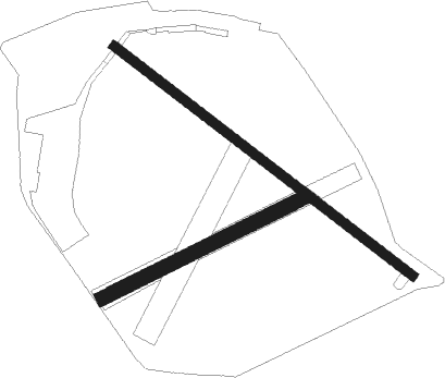
Runway 13 / 31  
 length800m (2625ft)
 bearing117° / 297°
 width20m (66ft)
 surfaceasphalt
Runway 06 / 24  
 length470m (1542ft)
 bearing77° / 257°
 width30m (98ft)
 surfacegrass

Airport layout


Parking locations

Nearby beacons

codeidentifierdistbearingfrequency
LJULJUNGBYHED VOR/DME14.7331°113.40
SUPSTURUP (MALMO) VOR/DME18.9171°113
KDKRISTIANSTAD NDB25.288°375
OEMKRISTIANSTAD NDB27.280°363
KASKASTRUP (COPENHAGEN) VOR/DME28.7250°112.50
AHANGELHOLM NDB28.9314°417
SVDDME31.8293°116.20
LBANGELHOLM NDB35.4311°370
MFHALMSTAD NDB51.3327°421
LTHALMSTAD NDB59.2333°336
CDACODAN VOR/DME60.3228°114.90

Disclaimer

The information on this website is not for real aviation. Use this data with the X-Plane flight simulator only! Data taken with kind consent from X-Plane 12 source code and data files. Content is subject to change without notice.