Airports for X-Plane offers a convenient way to explore airports and their related communication information for the X-Plane flight simulator. It only uses data from the X-Plane flight simulator itself, and is therefore more reliable than the data that comes from real aviation websites. You can search for airports by using the ICAO code, or browse for airports per country and state. The information displayed is categorized by airport details, runway information, airport communication, approach frequencies (ILS and Glidepath details), details of nearby beacons, SIDs, STARs and approach procedures.

warfare stol rail kennedy taxiway ferry gravel plane consulate train landing area landing hospital airspace embassy stopover buildings airfield traffic pattern terminal seaplanes

Visingsö - Visingso

Airport details

CountrySweden
StateJönköpings län
RegionES
AirspaceSweden Ctr
MunicipalityJönköpings kommun
Elevation309ft (94m)
TimezoneGMT +1
Coordinates58.09861, 14.40250
Magnetic var
Typeland
Available sinceX-Plane v10.40
ICAO codeESSI
IATA coden/a
FAA coden/a

Communication

Visingso COM freq123.500
Nearby Points of Interest:
Visingsö socken
-
Rysskyrkogården
-
Gränna Church
-
Brandstorp socken
-
Gränna socken
-
Södra Fågelås Church
-
Södra Fågelås socken
-
Östanå herrgård
-
Adelövs socken
-
Ölmstad Church
-
Ölmstads socken
-
Norra Fågelås socken
-
Ödeshögs socken
-
Östergötlands runinskrifter 144
-
Daretorps socken
-
Hjo socken
-
Trafik
-
Stora Åby
-
Skärstads socken
-
Östergötlands runinskrifter 133
-
Haurida socken
-
Lyckås
-
Vireda socken
-
Västra Tollstads socken
-
Gustav Adolfs socken

Runway info

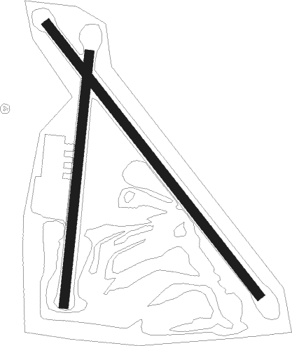
Runway 15 / 33  
 length931m (3054ft)
 bearing128° / 308°
 width25m (82ft)
 surfacegrass
Runway 01 / 19  
 length680m (2231ft)
 bearing19° / 199°
 width25m (82ft)
 surfacegrass

Airport layout


Nearby beacons

codeidentifierdistbearingfrequency
OAJONKOPING NDB18.7227°338
SSSKOVDE NDB20.8295°390
JONJONKOPING VOR/DME22.9225°115.80
KBGKARLSBORG NDB23.1357°312
OJJONKOPING NDB26.9223°403
NSSKOVDE NDB28.5317°384

Disclaimer

The information on this website is not for real aviation. Use this data with the X-Plane flight simulator only! Data taken with kind consent from X-Plane 12 source code and data files. Content is subject to change without notice.