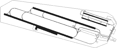
Ljungbyhed
Airport details
| Country | Sweden |
| State | Skåne län |
| Region | ES |
| Airspace | Sweden Ctr |
| Municipality | Klippans kommun |
| Elevation | 140ft (43m) |
| Timezone | GMT +1 |
| Coordinates | 56.07753, 13.22280 |
| Magnetic var | |
| Type | land |
| Available since | X-Plane v10.40 |
| ICAO code | ESTL |
| IATA code | n/a |
| FAA code | n/a |
Communication
| Ljungbyhed ATIS | 132.750 |
| Ljungbyhed Ground Control | 121.650 |
| Ljungbyhed Tower | 129.700 |
| Ljungbyhed Tower | 130.700 |
| Ljungbyhed Approach | 129.550 |
Approach frequencies
| ILS-cat-I | RW29L | 111.7 | 18.00mi |
| 3° GS | RW29L | 111.7 | 18.00mi |
Runway info
Nearby beacons
| code | identifier | dist | bearing | frequency |
|---|---|---|---|---|
| LJU | LJUNGBYHED VOR/DME | 0.7 | 285° | 113.40 |
| AH | ANGELHOLM NDB | 15.6 | 300° | 417 |
| LB | ANGELHOLM NDB | 22.2 | 301° | 370 |
| SVD | DME | 22.4 | 278° | 116.20 |
| OEM | KRISTIANSTAD NDB | 29.9 | 96° | 363 |
| KD | KRISTIANSTAD NDB | 31.3 | 104° | 375 |
| SUP | STURUP (MALMO) VOR/DME | 33 | 164° | 113 |
| KAS | KASTRUP (COPENHAGEN) VOR/DME | 35.7 | 231° | 112.50 |
| MF | HALMSTAD NDB | 37.1 | 324° | 421 |
| LT | HALMSTAD NDB | 45 | 332° | 336 |
Departure and arrival routes
| Transition altitude | 5000ft |
| SID end points | distance | outbound heading | |
|---|---|---|---|
| RW11R | |||
| OEM2B | 30mi | 96° | |
| INRE1B | 14mi | 267° | |
| RW29L | |||
| OEM2C | 30mi | 96° | |
| STAR starting points | distance | inbound heading | |
|---|---|---|---|
| RW11R | |||
| NEXI2E | 23.1 | 243° | |
| MAXU2E | 28.1 | 318° | |
| RW29L | |||
| MAXU2F | 28.1 | 318° | |
Disclaimer
The information on this website is not for real aviation. Use this data with the X-Plane flight simulator only! Data taken with kind consent from X-Plane 12 source code and data files. Content is subject to change without notice.

