Reichenbach - Baumholder Army Airfield
Airport details
| Country | Germany |
| State | Rhineland-Palatinate |
| Region | ED |
| Airspace | Langen Ctr |
| Municipality | Reichenbach |
| Elevation | 1419ft (433m) |
| Timezone | GMT +1 |
| Coordinates | 49.65151, 7.30709 |
| Magnetic var | |
| Type | land |
| Available since | X-Plane v10.40 |
| ICAO code | ETEK |
| IATA code | n/a |
| FAA code | n/a |
Communication
Nearby Points of Interest:
Church of Reichenbach, near Baumholder
-Saint Simon and Jude Thaddaeus, Baumholder
-Evangelical Church Baumholder
-Kirche Niederbrombach
-Jüdischer Friedhof
-Bahnhof Ulmet
-St. Laurentius
-Bahnhof Eschenau (Pfalz)
-St. Katharina
-Protestant Church (Sensweiler)
-Niedereisenbach-Hachenbach railway station
-Reitscheider Kreuz
-Protestant Church (Bruchweiler)
-Burg Grumbach
-Evangelische Kirche (Hoof)
-Steinkallenfels Castle
-Bahnhof Hoxel
-Schloss Lauterecken
-Alter Bahnhof
-Margarethenkirche
-Protestant Church (Bollenbach)
-Protestant Church (Stipshausen)
-Paqué brewery, St. Wendel
-St. Anna
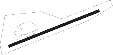
Runway info
| Runway 07 / 25 | ||
| length | 574m (1883ft) | |
| bearing | 79° / 259° | |
| width | 16m (52ft) | |
| surface | asphalt | |
Nearby beacons
| code | identifier | dist | bearing | frequency |
|---|---|---|---|---|
| RMS | RAMSTEIN TACAN | 16.9 | 128° | 113.40 |
| FHH | DME | 17.5 | 351° | 117.35 |
| HAN | HAHN NDB | 18.8 | 355° | 376 |
| ZWN | ZWEIBRUECKEN VOR/DME | 25.7 | 165° | 114.80 |
| SR | ENSHEIM (SAARBRUECKEN) NDB | 26.2 | 191° | 360 |
| SAD | DME | 27.4 | 204° | 116.75 |
| SPA | SPANGDAHLEM TACAN | 30.7 | 298° | 109.50 |
| BUE | BUECHEL TACAN | 32.9 | 336° | 117.10 |
| ELU | LUXEMBOURG NDB | 37 | 272° | 368 |
| GTQ | GROSTENQUIN VOR/DME | 46.1 | 222° | 111.25 |
| TAU | TAUNUS VOR/DME | 48.8 | 55° | 113.35 |
| SAV | SAVERNE VOR/DME | 51.6 | 171° | 110.45 |
| PHG | PHALSBOURG NDB | 53.2 | 187° | 424 |
| KBA | KARLSRUHE/BADEN-BADEN NDB | 59.9 | 137° | 431 |
| KBD | DME | 60.6 | 138° | 115.80 |
Disclaimer
The information on this website is not for real aviation. Use this data with the X-Plane flight simulator only! Data taken with kind consent from X-Plane 12 source code and data files. Content is subject to change without notice.