Niederstetten
Airport details
| Country | Germany |
| State | Baden-Württemberg |
| Region | ED |
| Airspace | Langen Ctr |
| Municipality | Niederstetten |
| Elevation | 1536ft (468m) |
| Timezone | GMT +1 |
| Coordinates | 49.39106, 9.96009 |
| Magnetic var | |
| Type | land |
| Available since | X-Plane v10.40 |
| ICAO code | ETHN |
| IATA code | n/a |
| FAA code | n/a |
Communication
| Niederstetten Langen Info | 128.950 |
| Niederstetten Stetten Tower | 122.100 |
Approach frequencies
| ILS-cat-I | RW25 | 108.9 | 18.00mi |
| 3.4° GS | RW25 | 108.9 | 18.00mi |
Nearby Points of Interest:
City fortifications of Niederstetten
-Niederstettener Tunnel
-Jüdischer Friedhof
-Schlösschen Pfitzingen
-Schwabenmühle
-Romschlösschen
-City fortifications of Creglingen
-Synagogue (Weikersheim)
-City fortifications of Weikersheim
-Tauberzell 11
-Rathaus
-Klosterhof 5, Konventsgebäude
-Judengasse 10
-Herrngasse 1 (Rothenburg ob der Tauber)
-Town hall of Rothenburg ob der Tauber
-Hofbronnengasse 13
-Ansbacher Straße 2 (Rothenburg ob der Tauber)
-Dominikanerkloster Mergentheim
-Lothar-Daiker-Straße 1
-Evangelisch-lutherisches Pfarrhaus (Gattenhofen)
-City fortifications of Bad Mergentheim
-Dreifaltigkeitsbildstock (Meßbach)
-Synagoge
-Dreifaltigkeitskirche Meßbach
Runway info
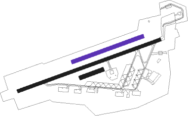
Runway 07R / 25L  | ||
| length | 193m (633ft) | |
| bearing | 80° / 260° | |
| width | 37m (121ft) | |
| surface | grass | |
| Runway 07L / 25R | ||
| length | 638m (2093ft) | |
| bearing | 80° / 260° | |
| width | 33m (108ft) | |
| surface | grass | |
| Runway 07 / 25 | ||
| length | 1307m (4288ft) | |
| bearing | 80° / 260° | |
| width | 30m (98ft) | |
| surface | asphalt | |
| displ threshold | 0m (0ft) / 102m (335ft) | |
| blast zone | 59m (194ft) / 0m (0ft) | |
Nearby beacons
| code | identifier | dist | bearing | frequency |
|---|---|---|---|---|
| NDD | DME-ILS | 0.1 | 16° | 108.70 |
| NSN | NIEDERSTETTEN NDB | 0.2 | 53° | 311 |
| ILM | ILLESHEIM NDB | 17.4 | 79° | 488 |
| SHD | HALL DME | 17.9 | 214° | 108.05 |
| DKB | DINKELSBUEHL VORTAC | 18.4 | 132° | 117.80 |
| ANS | ANSBACH NDB | 26.7 | 97° | 452 |
| LBU | LUBURG VOR/DME | 37.6 | 232° | 109.20 |
| CHA | CHARLIE VOR/DME | 47.8 | 300° | 115.35 |
| STG | STUTTGART VOR/DME | 50 | 225° | 116.85 |
| SGD | DME | 51.2 | 226° | 115.45 |
| TGO | TANGO TACAN | 53.9 | 222° | 112.50 |
| AGB | AUGSBURG NDB | 69.6 | 135° | 318 |
| AUG | DME | 69.6 | 135° | 115.90 |
Instrument approach procedures
| runway | airway (heading) | route (dist, bearing) |
|---|---|---|
| RW07 | NIBKO (141°) | NIBKO 4000ft HN401 (9mi, 255°) 4000ft HN402 (6mi, 156°) 3000ft |
| RNAV | HN402 3000ft UMKAB (6mi, 80°) 3000ft ETHN (5mi, 80°) 1578ft HN403 (4mi, 79°) NIBKO (9mi, 294°) 4000ft | |
| RW25 | TIMLO (179°) | TIMLO 4000ft HN421 (8mi, 89°) 4000ft HN422 (5mi, 157°) 3000ft |
| RNAV | HN422 3000ft NENVU (5mi, 260°) 3000ft ETHN (4mi, 259°) 1585ft HN423 (5mi, 260°) TIMLO (10mi, 40°) 4000ft |
Disclaimer
The information on this website is not for real aviation. Use this data with the X-Plane flight simulator only! Data taken with kind consent from X-Plane 12 source code and data files. Content is subject to change without notice.