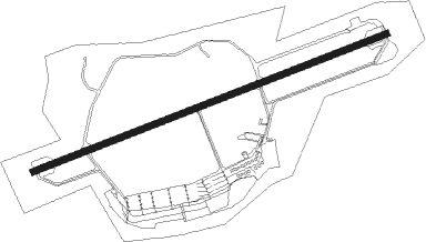
Wiesbaden - Wiesbaden Erbenheim Aaf
Airport details
| Country | Germany |
| State | Hesse |
| Region | ED |
| Airspace | Langen Ctr |
| Municipality | Wiesbaden |
| Elevation | 458ft (140m) |
| Timezone | GMT +1 |
| Coordinates | 50.04984, 8.32550 |
| Magnetic var | |
| Type | land |
| Available since | X-Plane v10.40 |
| ICAO code | ETOU |
| IATA code | UWE |
| FAA code | n/a |
Communication
| Wiesbaden Erbenheim AAF Wiesbaden ATIS | 292.750 |
| Wiesbaden Erbenheim AAF Wiesbaden Gr. Contr. (fictional) | 128.800 |
| Wiesbaden Erbenheim AAF Wiesbaden Ground Control | 313.550 |
| Wiesbaden Erbenheim AAF Wiesbaden Tower | 122.100 |
| Wiesbaden Erbenheim AAF Wiesbaden Tower | 278.150 |
| Wiesbaden Erbenheim AAF Frankfurt Radar | 120.800 |
| Wiesbaden Erbenheim AAF Frankfurt Radar | 399.550 |
Approach frequencies
| ILS-cat-I | RW25 | 108.5 | 18.00mi |
| 3° GS | RW25 | 108.5 | 18.00mi |
Nearby beacons
| code | identifier | dist | bearing | frequency |
|---|---|---|---|---|
| WIB | WIESBADEN TACAN | 0.6 | 256° | 114.10 |
| FW | FRANKFURT NDB | 4.8 | 113° | 382 |
| VFM | NAUHEIM VOR | 7.7 | 121° | 113.75 |
| FRD | DME | 9.4 | 95° | 115.90 |
| FFM | FRANKFURT VORTAC | 12 | 89° | 114.20 |
| TAU | TAUNUS VOR/DME | 13.5 | 321° | 113.35 |
| FR | FRANKFURT NDB | 13.8 | 87° | 297 |
| RID | RIED VOR/DME | 18.1 | 141° | 112.20 |
| MTR | METRO VOR | 24.2 | 67° | 110 |
| CHA | CHARLIE VOR/DME | 28.6 | 100° | 115.35 |
| MND | DME | 35.5 | 162° | 113.55 |
| SIL | SIEGERLAND NDB | 38.5 | 343° | 489 |
| SLD | DME | 40.5 | 339° | 108.05 |
| GED | GEDERN VORTAC | 41.6 | 69° | 110.80 |
| NKR | NECKAR NDB | 45.6 | 150° | 292 |
| RMS | RAMSTEIN TACAN | 46.7 | 230° | 113.40 |
| COL | COLA VOR/DME | 52.1 | 315° | 108.80 |
| ZWN | ZWEIBRUECKEN VOR/DME | 60.6 | 228° | 114.80 |
Departure and arrival routes
| Transition altitude | 5000ft |
| SID end points | distance | outbound heading | |
|---|---|---|---|
| RW07 | |||
| TABU2X | 15mi | 18° | |
| UBEN2X | 23mi | 131° | |
| RID2X | 18mi | 141° | |
| SOBR2X | 24mi | 251° | |
| MASI2X | 26mi | 289° | |
| RW25 | |||
| TABU2W, TABU1V | 15mi | 18° | |
| UBEN1V, UBEN2W | 23mi | 131° | |
| RID2W, RID1V | 18mi | 141° | |
| SOBR1V, SOBR2W | 24mi | 251° | |
| MASI2W, MASI1V | 26mi | 289° | |
Instrument approach procedures
| runway | airway (heading) | route (dist, bearing) |
|---|---|---|
| RW07 | OU455 (141°) | OU455 OU452 (12mi, 227°) OU451 (6mi, 156°) 3500ft |
| RNAV | OU451 3500ft ELTIL (5mi, 79°) 2600ft SR07 (5mi, 79°) 1120ft ETOU (3mi, 79°) 504ft (3036mi, 189°) 860ft OU453 (3037mi, 10°) 4300ft OU455 (14mi, 309°) 5000ft OU455 (turn) | |
| RW25 | MTR (247°) | MTR 4000ft OU421 (10mi, 250°) 3000ft OU420 (7mi, 215°) 3000ft |
| RNAV | OU420 3000ft BASDA (4mi, 259°) 2000ft OU401 (2mi, 259°) 1240ft ETOU (3mi, 259°) 509ft (3036mi, 189°) 860ft OU425 (3034mi, 9°) 2500ft EROVO (7mi, 259°) 4000ft OU455 (17mi, 29°) MTR (26mi, 88°) 5000ft MTR (turn) |
Disclaimer
The information on this website is not for real aviation. Use this data with the X-Plane flight simulator only! Data taken with kind consent from X-Plane 12 source code and data files. Content is subject to change without notice.
