Vilnius - Kyviškes
Airport details
| Country | Lithuania |
| State | Vilnius County |
| Region | EY |
| Airspace | Vilnius Ctr |
| Municipality | Kyviškės |
| Elevation | 520ft (158m) |
| Timezone | GMT +2 |
| Coordinates | 54.66800, 25.51600 |
| Magnetic var | |
| Type | land |
| Available since | X-Plane v10.40 |
| ICAO code | EYVK |
| IATA code | n/a |
| FAA code | n/a |
Communication
| Kyviškes ATIS | 125.800 |
| Kyviškes Kyviskes Radio | 122.850 |
Nearby Points of Interest:
Holy Trinity church in Hiermaniški
-Church of the Visitation of the Blessed Virgin Mary in Hudahaj
-Church of the Nativity of the Virgin Mary in Kiemieliški
-Church of Saint George in Varniany
-Church of Saints Apostles Peter and Paul, Župrany
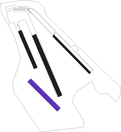
Runway info
| Runway 13R / 31L | ||
| length | 393m (1289ft) | |
| bearing | 124° / 304° | |
| width | 50m (164ft) | |
| surface | grass | |
Runway 15 / 33  | ||
| length | 656m (2152ft) | |
| bearing | 150° / 330° | |
| width | 44m (145ft) | |
| surface | grass | |
| Runway 13L / 31R | ||
| length | 532m (1745ft) | |
| bearing | 125° / 305° | |
| width | 23m (75ft) | |
| surface | asphalt | |
| blast zone | 3m (10ft) / 10m (33ft) | |
| Runway 15R / 33L | ||
| length | 392m (1286ft) | |
| bearing | 150° / 330° | |
| width | 37m (120ft) | |
| surface | grass | |
Nearby beacons
| code | identifier | dist | bearing | frequency |
|---|---|---|---|---|
| AVN | VILNIUS NDB | 6.9 | 274° | 385 |
| VNO | VILNIUS VOR/DME | 7.9 | 262° | 113.80 |
| PBZ | DME | 18.2 | 313° | 117.25 |
| SML | DME | 28.6 | 271° | 112.50 |
| VLK | DME | 31.3 | 246° | 116.70 |
Disclaimer
The information on this website is not for real aviation. Use this data with the X-Plane flight simulator only! Data taken with kind consent from X-Plane 12 source code and data files. Content is subject to change without notice.