Iowa Park - Wichita Valley
Airport details
| Country | United States of America |
| State | Texas |
| Region | K4 |
| Airspace | Ft Worth Ctr |
| Municipality | Pleasant Valley |
| Elevation | 1001ft (305m) |
| Timezone | GMT -6 |
| Coordinates | 33.94761, -98.61615 |
| Magnetic var | |
| Type | land |
| Available since | X-Plane v10.40 |
| ICAO code | F14 |
| IATA code | n/a |
| FAA code | n/a |
Communication
| Wichita Valley CTAF/UNICOM | 122.800 |
| Wichita Valley SHEPPARD Approach/Departure | 118.200 |
Nearby Points of Interest:
Archer County Courthouse and Jail
-State Highway 79 Bridge at the Red River
-Irving Baptist Church
-Tillman County Courthouse
-First Presbyterian Church
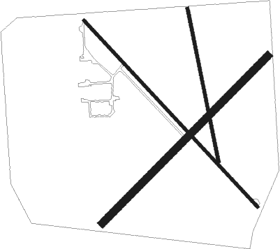
Runway info
Runway 13 / 31  | ||
| length | 1013m (3323ft) | |
| bearing | 136° / 316° | |
| width | 12m (40ft) | |
| surface | asphalt | |
| Runway 04 / 22 | ||
| length | 937m (3074ft) | |
| bearing | 54° / 234° | |
| width | 30m (100ft) | |
| surface | grass | |
| Runway 16 / 34 | ||
| length | 622m (2041ft) | |
| bearing | 172° / 352° | |
| width | 13m (42ft) | |
| surface | grass | |
Nearby beacons
| code | identifier | dist | bearing | frequency |
|---|---|---|---|---|
| SPS | WICHITA FALLS VORTAC | 2.6 | 30° | 112.70 |
| SHP | SHEPPARD (WICHITA FALLS) TACAN | 6.7 | 75° | 110.80 |
| SKB | SCOTLAND (WICHITA FALLS) NDB | 11.8 | 142° | 344 |
| LAW | LAWTON VOR/DME | 34.4 | 20° | 109.40 |
| DUC | DME | 43.5 | 58° | 111 |
| UKW | BOWIE VORTAC | 46.7 | 117° | 117.15 |
| GHX | GRAHAM NDB | 47.3 | 171° | 371 |
| LTS | ALTUS VORTAC | 53.8 | 318° | 109.80 |
| HBR | HOBART VORTAC | 59.4 | 334° | 111.80 |
Disclaimer
The information on this website is not for real aviation. Use this data with the X-Plane flight simulator only! Data taken with kind consent from X-Plane 12 source code and data files. Content is subject to change without notice.