Polk City - Worlds Greatest Aircraft Collection
Airport details
| Country | United States of America |
| State | Florida |
| Region | |
| Airspace | Miami Oceanic Ctr |
| Municipality | Polk County |
| Elevation | 139ft (42m) |
| Timezone | GMT -5 |
| Coordinates | 28.15824, -81.81679 |
| Magnetic var | |
| Type | land |
| Available since | X-Plane v10.40 |
| ICAO code | FA08 |
| IATA code | n/a |
| FAA code | FA08 |
Communication
Nearby Points of Interest:
Holland Jenks House
-Auburndale Citrus Growers Association Packing House
-Interlaken Historic Residential District
-Pope Avenue Historic District
-Downtown Winter Haven Historic District
-Winter Haven Heights Historic Residential District
-Biltmore-Cumberland Historic District
-Frances Langford Promenade
-Old Lakeland High School
-East Lake Morton Residential District
-Polk Theatre
-Oates Building
-Child of the Sun
-South Lake Morton Historic District
-Downtown Haines City Commercial District
-St. Mark's Episcopal Church
-Old Central Grammar School
-Dixieland Historic District
-Lake Hunter Terrace Historic District
-Beacon Hill-Alta Vista Residential District
-Davenport Historic District
-Old Dundee Atlantic Coast Line Railroad Depot
-Northeast Bartow Residential District
-John J. Swearingen House
-Old Polk County Courthouse
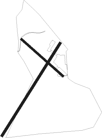
Runway info
Runway 04 / 22  | ||
| length | 1498m (4915ft) | |
| bearing | 40° / 220° | |
| width | 38m (125ft) | |
| surface | grass | |
| Runway 14 / 32 | ||
| length | 760m (2493ft) | |
| bearing | 132° / 312° | |
| width | 30m (100ft) | |
| surface | grass | |
Nearby beacons
| code | identifier | dist | bearing | frequency |
|---|---|---|---|---|
| LAL | LAKELAND VORTAC | 14.6 | 229° | 116 |
| OR | HERNY (ORLANDO) NDB | 29.1 | 48° | 221 |
| ORL | ORLANDO VORTAC | 34.3 | 51° | 112.20 |
| TP | COSME (TAMPA) NDB | 37.7 | 264° | 368 |
| MCF | MACDILL (TAMPA) TACAN | 41 | 247° | 111 |
| PI | CAPOK(ST PETERSBURG-CLEARWATER NDB | 48 | 260° | 360 |
| PIE | SAINT PETERSBURG VORTAC | 48.3 | 254° | 116.40 |
| SRQ | SARASOTA VOR/DME | 60 | 225° | 117 |
Disclaimer
The information on this website is not for real aviation. Use this data with the X-Plane flight simulator only! Data taken with kind consent from X-Plane 12 source code and data files. Content is subject to change without notice.