Naples - Wing South Airpark
Airport details
| Country | United States of America |
| State | Florida |
| Region | |
| Airspace | Miami Oceanic Ctr |
| Municipality | Collier County |
| Elevation | 6ft (2m) |
| Timezone | GMT -5 |
| Coordinates | 26.12265, -81.70236 |
| Magnetic var | |
| Type | land |
| Available since | X-Plane v10.40 |
| ICAO code | FA37 |
| IATA code | n/a |
| FAA code | FA37 |
Communication
Nearby Points of Interest:
Seaboard Coast Line Railroad Depot
-Naples Historic District
-Bank of Everglades Building
-Old Collier County Courthouse
-Jewett-Thompson House
-Casa Rio
-William H. Towles House
-Old Lee County Courthouse
-Murphy-Burroughs House
-Alderman House
-Buckingham School
-Menge-Hansen Marine Ways
-Tween Waters Inn Historic District
-Captiva School and Chapel-by-the-Sea Historic District
-Alva Consolidated Schools
-Monroe Station
-Wilderness Waterway
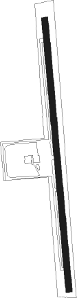
Runway info
| Runway 18 / 36 | ||
| length | 1347m (4419ft) | |
| bearing | 179° / 359° | |
| width | 30m (100ft) | |
| surface | asphalt | |
| displ threshold | 92m (302ft) / 93m (305ft) | |
Nearby beacons
| code | identifier | dist | bearing | frequency |
|---|---|---|---|---|
| CYY | CYPRESS (NAPLES) VOR/DME | 4.4 | 292° | 108.60 |
| RSW | LEE COUNTY (FORT MYERS) VORTAC | 24.7 | 350° | 111.80 |
| FM | CALOO (FORT MYERS) NDB | 27.1 | 328° | 341 |
| LBV | LA BELLE VORTAC | 45.5 | 24° | 110.40 |
| PGD | PUNTA GORDA VOR | 50.1 | 340° | 110.20 |
Disclaimer
The information on this website is not for real aviation. Use this data with the X-Plane flight simulator only! Data taken with kind consent from X-Plane 12 source code and data files. Content is subject to change without notice.