Bloemfontain - Bloemfontein
Airport details
| Country | South Africa |
| State | Free State |
| Region | FA |
| Airspace | Johannesburg Ctr |
| Municipality | Bloemfontein |
| Elevation | 4592ft (1400m) |
| Timezone | GMT +2 |
| Coordinates | -29.09556, 26.30507 |
| Magnetic var | |
| Type | land |
| Available since | X-Plane v10.40 |
| ICAO code | FABL |
| IATA code | BFN |
| FAA code | n/a |
Communication
| Bloemfontein ATIS | 126.650 |
| Bloemfontein Tower | 120.800 |
| Bloemfontein Approach | 124.300 |
Nearby Points of Interest:
Fourth Raadsaal
-Bloemfontein City Hall
-National Women's Monument
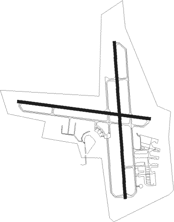
Runway info
Runway 02 / 20  | ||
| length | 2570m (8432ft) | |
| bearing | 0° / 180° | |
| width | 46m (151ft) | |
| surface | asphalt | |
| blast zone | 59m (194ft) / 59m (194ft) | |
| Runway 12 / 30 | ||
| length | 2195m (7201ft) | |
| bearing | 100° / 280° | |
| width | 46m (151ft) | |
| surface | asphalt | |
Nearby beacons
| code | identifier | dist | bearing | frequency |
|---|---|---|---|---|
| BLV | BLOEMFONTEIN VORTAC | 0.3 | 221° | 114.10 |
Departure and arrival routes
| Transition altitude | 8000ft |
| SID end points | distance | outbound heading | |
|---|---|---|---|
| RW02 | |||
| OKTI1B | 45mi | 37° | |
| STAR starting points | distance | inbound heading | |
|---|---|---|---|
| RW02 | |||
| UTON1A | 29.7 | 246° | |
Instrument approach procedures
| runway | airway (heading) | route (dist, bearing) |
|---|---|---|
| RW02 | EGPID (34°) | EGPID 8000ft BL1T1 (6mi, 90°) 6100ft |
| RW02 | IBMAD (328°) | IBMAD 8000ft BL1T1 (6mi, 270°) 6100ft |
| RW02 | UNRIM (1°) | UNRIM 8000ft BL1T1 (6mi, 0°) 6100ft |
| RNAV | BL1T1 6100ft BL1F1 (5mi, 0°) 6100ft BL1MP (5mi, 0°) 4463ft (2309mi, 318°) 6500ft IBMAD (2320mi, 138°) 8000ft IBMAD (turn) 8000ft | |
| RW20 | DUGSO (147°) | DUGSO 8000ft BL2T1 (6mi, 90°) 6500ft |
| RW20 | IMGUR (180°) | IMGUR 8000ft BL2T1 (6mi, 180°) 6500ft |
| RW20 | UNLOD (212°) | UNLOD 8000ft BL2T1 (6mi, 270°) 6500ft |
| RNAV | BL2T1 6500ft BL2F1 (5mi, 180°) 6000ft BL2MP (5mi, 180°) 4471ft (2308mi, 318°) 6500ft UNLOD (2305mi, 138°) 8000ft UNLOD (turn) 8000ft |
Holding patterns
| STAR name | hold at | type | turn | heading* | altitude | leg | speed limit |
|---|---|---|---|---|---|---|---|
| UTON1A | UTONU | VHF | left | 63 (243)° | 15000ft - 20000ft | 1.5min timed | 230 |
| *) magnetic outbound (inbound) holding course | |||||||
Disclaimer
The information on this website is not for real aviation. Use this data with the X-Plane flight simulator only! Data taken with kind consent from X-Plane 12 source code and data files. Content is subject to change without notice.