Ceres
Airport details
| Country | South Africa |
| State | Western Cape |
| Region | |
| Airspace | Cape Town Ctr |
| Municipality | Witzenberg Local Municipality |
| Elevation | 1961ft (598m) |
| Timezone | GMT +2 |
| Coordinates | -33.31868, 19.42094 |
| Magnetic var | |
| Type | land |
| Available since | X-Plane v10.40 |
| ICAO code | FACE |
| IATA code | n/a |
| FAA code | n/a |
Communication
Nearby Points of Interest:
Groot Winterhoek
-Bain's Kloof Pass
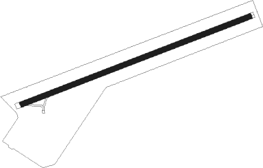
Runway info
| Runway 10 / 28 | ||
| length | 1500m (4921ft) | |
| bearing | 76° / 256° | |
| width | 32m (105ft) | |
| surface | grass | |
| blast zone | 46m (151ft) / 30m (98ft) | |
Nearby beacons
| code | identifier | dist | bearing | frequency |
|---|---|---|---|---|
| CSV | CERES VOR/DME | 4 | 15° | 114.20 |
| WC | WORCESTER NDB | 20.7 | 181° | 335 |
| SVV | SOMERSVELD VOR | 47.5 | 274° | 113 |
| CDV | CALEDON VOR | 47.7 | 176° | 114.90 |
| CB | CAPE TOWN NDB | 54 | 237° | 462 |
| CTV | CAPE TOWN VOR/DME | 56.5 | 231° | 115.70 |
Disclaimer
The information on this website is not for real aviation. Use this data with the X-Plane flight simulator only! Data taken with kind consent from X-Plane 12 source code and data files. Content is subject to change without notice.