Fisantekraal - Fisantekraal Airfield
Airport details
| Country | South Africa |
| State | Western Cape |
| Region | FA |
| Airspace | Cape Town Ctr |
| Municipality | City of Cape Town |
| Elevation | 399ft (122m) |
| Timezone | GMT +2 |
| Coordinates | -33.77139, 18.74000 |
| Magnetic var | |
| Type | land |
| Available since | X-Plane v10.40 |
| ICAO code | FAFK |
| IATA code | n/a |
| FAA code | n/a |
Communication
| Fisantekraal Airfield Fisantekraal Traffic | 131.100 |
Nearby Points of Interest:
Boschendal
-Rondebosch Common
-Groote Schuur Hospital
-Cape Town City Hall
-Martin Melck House
-National Library of South Africa
-Rust en Vreugd
-Tuynhuys
-Huguenot Memorial Building
-Table Mountain
-Bain's Kloof Pass
-Cape Floristic Region
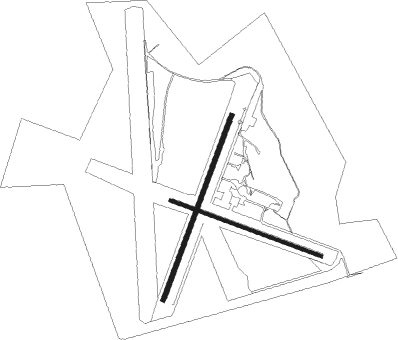
Runway info
Runway 05 / 23  | ||
| length | 901m (2956ft) | |
| bearing | 29° / 209° | |
| width | 20m (66ft) | |
| surface | hard surface | |
| blast zone | 66m (217ft) / 67m (220ft) | |
| Runway 14 / 32 | ||
| length | 736m (2415ft) | |
| bearing | 111° / 291° | |
| width | 16m (52ft) | |
| surface | hard surface | |
| blast zone | 58m (190ft) / 57m (187ft) | |
Nearby beacons
| code | identifier | dist | bearing | frequency |
|---|---|---|---|---|
| CB | CAPE TOWN NDB | 10.4 | 238° | 462 |
| CTV | CAPE TOWN VOR/DME | 13.6 | 214° | 115.70 |
| RIV | ROBBEN ISLAND VOR/DME | 18.8 | 266° | 117.60 |
| SVV | SOMERSVELD VOR | 33.9 | 333° | 113 |
| WC | WORCESTER NDB | 34.4 | 81° | 335 |
| CDV | CALEDON VOR | 42.1 | 115° | 114.90 |
| CSV | CERES VOR/DME | 46.8 | 53° | 114.20 |
| LWV | LANGEBAANWEG VOR/DME | 55.4 | 324° | 117 |
| LW | LANGEBAANWEG NDB | 55.9 | 323° | 345 |
Disclaimer
The information on this website is not for real aviation. Use this data with the X-Plane flight simulator only! Data taken with kind consent from X-Plane 12 source code and data files. Content is subject to change without notice.