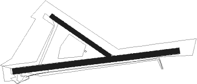
Fort Beaufort
Airport details
| Country | South Africa |
| State | Eastern Cape |
| Region | FA |
| Airspace | Cape Town Ctr |
| Municipality | Nkonkobe Local Municipality |
| Elevation | 1762ft (537m) |
| Timezone | GMT +2 |
| Coordinates | -32.79078, 26.57739 |
| Magnetic var | |
| Type | land |
| Available since | X-Plane v10.40 |
| ICAO code | FAFO |
| IATA code | n/a |
| FAA code | n/a |
Communication
| Fort Beaufort East London FAEL ATIS | 126.650 |
| Fort Beaufort AREA Frequency | 124.800 |
Instrument approach procedures
| runway | airway (heading) | route (dist, bearing) |
|---|---|---|
| RW11 | AVEPA (114°) | AVEPA 6800ft FO1T1 (6mi, 177°) 4900ft |
| RW11 | TEXER (88°) | TEXER 6500ft FO1T1 (6mi, 88°) 4900ft |
| RW11 | UVGED (62°) | UVGED 6200ft FO1T1 (6mi, 357°) 4900ft |
| RNAV | FO1T1 4900ft FO1F1 (5mi, 88°) 3200ft FO1SD (2mi, 88°) 2440ft FAFO (2mi, 87°) 1809ft FAFO (turn) 2170ft FO1M1 (10mi, 88°) 3900ft AVEPA (21mi, 282°) 6800ft AVEPA (turn) 6800ft | |
| RW29 | ANVOB (289°) | ANVOB 7000ft FO2T1 (6mi, 357°) 5400ft |
| RW29 | GEXUN (268°) | GEXUN 7500ft FO2T1 (6mi, 268°) 5400ft |
| RW29 | UVKIX (247°) | UVKIX 7700ft FO2T1 (6mi, 177°) 5400ft |
| RNAV | FO2T1 5400ft FO2F1 (7mi, 268°) 3400ft FAFO (6mi, 268°) 1764ft FAFO (turn) 2170ft FO2M1 (10mi, 268°) UVKIX (23mi, 76°) 7700ft UVKIX (turn) 7700ft |
Disclaimer
The information on this website is not for real aviation. Use this data with the X-Plane flight simulator only! Data taken with kind consent from X-Plane 12 source code and data files. Content is subject to change without notice.

