Graaff-reinet - Graaff Reinet
Airport details
| Country | South Africa |
| State | Eastern Cape |
| Region | FA |
| Airspace | Cape Town Ctr |
| Municipality | Camdeboo Local Municipality |
| Elevation | 2604ft (794m) |
| Timezone | GMT +2 |
| Coordinates | -32.19482, 24.54115 |
| Magnetic var | |
| Type | land |
| Available since | X-Plane v10.40 |
| ICAO code | FAGR |
| IATA code | n/a |
| FAA code | n/a |
Communication
| Graaff Reinet Unicom | 124.800 |
Runway info
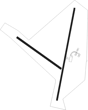
Runway 04 / 22  | ||
| length | 1501m (4925ft) | |
| bearing | 18° / 198° | |
| width | 23m (75ft) | |
| surface | asphalt | |
| Runway 15 / 33 | ||
| length | 855m (2805ft) | |
| bearing | 125° / 305° | |
| width | 30m (98ft) | |
| surface | gravel | |
Instrument approach procedures
| runway | airway (heading) | route (dist, bearing) |
|---|---|---|
| RW04 | APGUD (18°) | APGUD 6900ft GR1T1 (5mi, 70°) 5500ft |
| RW04 | EPMER (351°) | EPMER 6900ft GR1T1 (5mi, 345°) 5500ft |
| RW04 | UVLES (327°) | UVLES 8300ft GR1T1 (5mi, 267°) 5500ft |
| RNAV | GR1T1 5500ft GR1F1 (5mi, 345°) 4600ft GR1MP (5mi, 356°) 3007ft GR1M1 (4mi, 27°) GR1M2 (5mi, 97°) UVLES (12mi, 180°) 8300ft UVLES (turn) 8300ft |
Disclaimer
The information on this website is not for real aviation. Use this data with the X-Plane flight simulator only! Data taken with kind consent from X-Plane 12 source code and data files. Content is subject to change without notice.