Johannesburg - Lanseria
Airport details
| Country | South Africa |
| State | Gauteng |
| Region | FA |
| Airspace | Johannesburg Ctr |
| Municipality | City of Johannesburg Metropolitan Munici |
| Elevation | 4517ft (1377m) |
| Timezone | GMT +2 |
| Coordinates | -25.93795, 27.92440 |
| Magnetic var | |
| Type | land |
| Available since | X-Plane v10.40 |
| ICAO code | FALA |
| IATA code | HLA |
| FAA code | n/a |
Communication
Approach frequencies
| ILS-cat-I | RW07 | 110.7 | 18.00mi |
| 3° GS | RW07 | 110.7 | 18.00mi |
Nearby Points of Interest:
Swartkrans
-Gondolin Cave
-Plovers Lake
-Drimolen
-Gladysvale Cave
-Coopers Cave
-Paardekraal Monument
-Witwatersrand Gold Rush
-Weskoppies Psychiatric Hospital
-Johannesburg City Library
-Chancellor House
-James Mpanza House
-Palace of Justice (South Africa)
-Ou Raadsaal
-Union Buildings
-Van Wouw Museum
-Old Merensky Library
-Pretoria National Botanical Garden
-Witkop Blockhouse
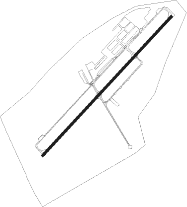
Runway info
| Runway 07 / 25 | ||
| length | 2999m (9839ft) | |
| bearing | 50° / 230° | |
| width | 45m (148ft) | |
| surface | asphalt | |
| displ threshold | 0m (0ft) / 70m (230ft) | |
Nearby beacons
| code | identifier | dist | bearing | frequency |
|---|---|---|---|---|
| LIV | LANSERIA VOR/DME | 0.8 | 225° | 117.40 |
| LA | LANSERIA NDB | 6.3 | 230° | 270 |
| GC | GRAND CENTRAL NDB | 12 | 104° | 372 |
| WKV | WATERKLOOF VOR/DME | 17.1 | 71° | 116.90 |
| JSV | JOHANNESBURG VOR/DME | 21.1 | 126° | 115.20 |
| RAV | RAND (JOHANNESBURG) VOR/DME | 22.2 | 143° | 117.70 |
| DPV | WONDERBOOM VOR/DME | 23.2 | 46° | 112.20 |
| RD | RAND (JOHANNESBURG) NDB | 24.2 | 156° | 307 |
| WR | WONDERBOOM (PRETORIA) NDB | 24.2 | 48° | 230 |
| WB | WONDERBOOM (PRETORIA) NDB | 26.3 | 53° | 257 |
| RA | RAND NDB | 34.4 | 145° | 337 |
| MEV | BRONKHORSTSPRUIT VOR/DME | 35.5 | 77° | 114.30 |
| CZV | ZONDERWATER VOR/DME | 37 | 68° | 114.30 |
| GAV | GRASMERE VOR | 37.1 | 203° | 115.50 |
| VV | VEREENIGING NDB | 37.8 | 177° | 460 |
| RG | RUSTENBURG NDB | 38.7 | 294° | 452 |
| HGV | HEIDELBERG VOR | 49.4 | 155° | 116.70 |
| PNV | PILANESBERG VOR/DME | 54.2 | 304° | 112.60 |
| STV | STANDERTON VOR | 68.2 | 129° | 116 |
Instrument approach procedures
| runway | airway (heading) | route (dist, bearing) |
|---|---|---|
| RW07 | LA1N1 (76°) | LA1N1 LA1T1 (7mi, 135°) 7700ft |
| RW07 | LA1N2 (50°) | LA1N2 LA1T1 (7mi, 51°) 7700ft |
| RW07 | LA1N3 (22°) | LA1N3 LA1T1 (7mi, 315°) 7700ft |
| RNAV | LA1T1 7700ft LA1F1 (5mi, 51°) 6700ft LA1MP (7mi, 51°) 4571ft LA1MP (turn) UTRUK (17mi, 343°) 8000ft | |
| RW25 | LA2N1 (124°) | LA2N1 9000ft LA2N2 (5mi, 50°) 7900ft LA2T1 (5mi, 114°) 6200ft |
| RW25 | LA2N2 (171°) | LA2N2 7900ft LA2T1 (5mi, 114°) 6200ft |
| RNAV | LA2T1 6200ft LA2F1 (2mi, 207°) 5600ft FALA (4mi, 232°) 4444ft LA1N2 (19mi, 230°) 8000ft LA1N2 (turn) 8000ft |
Disclaimer
The information on this website is not for real aviation. Use this data with the X-Plane flight simulator only! Data taken with kind consent from X-Plane 12 source code and data files. Content is subject to change without notice.