Newcastle
Airport details
| Country | South Africa |
| State | KwaZulu-Natal |
| Region | FA |
| Airspace | Johannesburg Ctr |
| Municipality | Newcastle Local Municipality |
| Elevation | 4074ft (1242m) |
| Timezone | GMT +2 |
| Coordinates | -27.77278, 29.97639 |
| Magnetic var | |
| Type | land |
| Available since | X-Plane v10.40 |
| ICAO code | FANC |
| IATA code | NCS |
| FAA code | n/a |
Communication
| Newcastle CTAF | 124.800 |
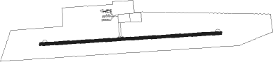
Runway info
| Runway 11 / 29 | ||
| length | 1501m (4925ft) | |
| bearing | 91° / 271° | |
| width | 23m (75ft) | |
| surface | asphalt | |
| displ threshold | 0m (0ft) / 101m (331ft) | |
Nearby beacons
| code | identifier | dist | bearing | frequency |
|---|---|---|---|---|
| NC | NEWCASTLE NDB | 0.2 | 358° | 415 |
| VHD | VRYHEID NDB | 39.1 | 91° | 230 |
| VHL | VRYHEID NDB | 43 | 91° | 350 |
| MAJ | MAJUBA NDB | 44.5 | 342° | 512 |
| WRV | WARDEN VOR | 48.1 | 270° | 112.80 |
| LYV | LADYSMITH VOR/DME | 52.1 | 199° | 116.50 |
| PRF | PIET RETIEF NDB | 65.5 | 44° | 525 |
Disclaimer
The information on this website is not for real aviation. Use this data with the X-Plane flight simulator only! Data taken with kind consent from X-Plane 12 source code and data files. Content is subject to change without notice.