Upington
Airport details
| Country | South Africa |
| State | Northern Cape |
| Region | FA |
| Airspace | Johannesburg Ctr |
| Municipality | ǁKhara Hais Local Municipality |
| Elevation | 2791ft (851m) |
| Timezone | GMT +2 |
| Coordinates | -28.40850, 21.25364 |
| Magnetic var | |
| Type | land |
| Available since | X-Plane v10.40 |
| ICAO code | FAUP |
| IATA code | UTN |
| FAA code | n/a |
Communication
| Upington APN | 122.650 |
| Upington Tower | 121.300 |
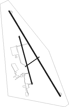
Runway info
Runway 17 / 35  | ||
| length | 4912m (16115ft) | |
| bearing | 151° / 331° | |
| width | 60m (197ft) | |
| surface | asphalt | |
| blast zone | 255m (837ft) / 255m (837ft) | |
| Runway 01 / 19 | ||
| length | 2444m (8018ft) | |
| bearing | 348° / 168° | |
| width | 46m (151ft) | |
| surface | asphalt | |
| Runway 08 / 26 | ||
| length | 828m (2717ft) | |
| bearing | 63° / 243° | |
| width | 30m (98ft) | |
| surface | asphalt | |
| blast zone | 255m (837ft) / 255m (837ft) | |
Nearby beacons
| code | identifier | dist | bearing | frequency |
|---|---|---|---|---|
| UPV | UPINGTON VOR/DME | 0.5 | 45° | 116.50 |
Instrument approach procedures
| runway | airway (heading) | route (dist, bearing) |
|---|---|---|
| RW35 | UP1N1 (346°) | UP1N1 6000ft UP1T1 (6mi, 26°) 4400ft |
| RW35 | UP1N2 (299°) | UP1N2 6000ft UP1T1 (6mi, 246°) 4400ft |
| RNAV | UP1T1 4400ft UP1F1 (5mi, 330°) 4400ft UP1MP (5mi, 331°) 2761ft UP1MP (turn) 4500ft UP1N1 (15mi, 171°) 6000ft |
Disclaimer
The information on this website is not for real aviation. Use this data with the X-Plane flight simulator only! Data taken with kind consent from X-Plane 12 source code and data files. Content is subject to change without notice.