Vryheid
Airport details
| Country | South Africa |
| State | KwaZulu-Natal |
| Region | |
| Airspace | Johannesburg Ctr |
| Municipality | Abaqulusi Local Municipality |
| Elevation | 3798ft (1158m) |
| Timezone | GMT +2 |
| Coordinates | -27.78576, 30.79079 |
| Magnetic var | |
| Type | land |
| Available since | X-Plane v10.40 |
| ICAO code | FAVY |
| IATA code | VYD |
| FAA code | n/a |
Communication
| Vryheid Vryheid Tower | 128.800 |
Runway info
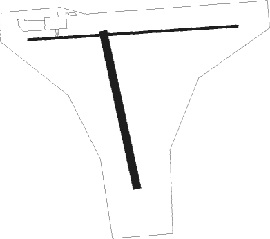
Runway 11 / 29  | ||
| length | 1235m (4052ft) | |
| bearing | 91° / 271° | |
| width | 13m (43ft) | |
| surface | asphalt | |
| Runway 01 / 19 | ||
| length | 908m (2979ft) | |
| bearing | 351° / 171° | |
| width | 45m (148ft) | |
| surface | grass | |
Nearby beacons
| code | identifier | dist | bearing | frequency |
|---|---|---|---|---|
| VHL | VRYHEID NDB | 0.2 | 265° | 350 |
| VHD | VRYHEID NDB | 4.1 | 270° | 230 |
| NC | NEWCASTLE NDB | 43.2 | 271° | 415 |
| SMH | ULUNDI NDB | 45.5 | 123° | 457 |
| UD | ULUNDI NDB | 46 | 129° | 267 |
| UL | DME | 46 | 130° | 115.40 |
| UL | ULUNDI NDB | 46.5 | 133° | 422 |
| PRF | PIET RETIEF NDB | 50.8 | 359° | 525 |
Disclaimer
The information on this website is not for real aviation. Use this data with the X-Plane flight simulator only! Data taken with kind consent from X-Plane 12 source code and data files. Content is subject to change without notice.