Garoua
Airport details
| Country | Cameroon |
| State | North |
| Region | FK |
| Airspace | N'djamena Ctr |
| Municipality | Garoua I |
| Elevation | 792ft (241m) |
| Timezone | GMT +1 |
| Coordinates | 9.33668, 13.38106 |
| Magnetic var | |
| Type | land |
| Available since | X-Plane v10.40 |
| ICAO code | FKKR |
| IATA code | GOU |
| FAA code | n/a |
Communication
| GAROUA Tower | 120.000 |
| GAROUA Tower | 118.300 |
Approach frequencies
| ILS-cat-II | RW09 | 109.5 | 18.00mi |
| 3° GS | RW09 | 109.5 | 18.00mi |
Runway info
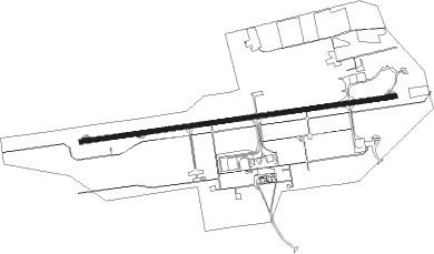
| Runway 09 / 27 | ||
| length | 3402m (11161ft) | |
| bearing | 86° / 266° | |
| width | 45m (148ft) | |
| surface | asphalt | |
| displ threshold | 0m (0ft) / 115m (377ft) | |
| blast zone | 140m (459ft) / 155m (509ft) | |
Nearby beacons
| code | identifier | dist | bearing | frequency |
|---|---|---|---|---|
| TJR | GAROUA VOR/DME | 2.1 | 266° | 112.30 |
| YOL | YOLA VOR/DME | 56.7 | 267° | 115.50 |
Departure and arrival routes
| Transition altitude | 3700ft |
| STAR starting points | distance | inbound heading | |
|---|---|---|---|
| ALL | |||
| ASAM1V | 84.9 | 19° | |
| AGRO1V | 99.1 | 36° | |
| ETRI1V | 27.5 | 94° | |
| EBIM1V | 42.9 | 172° | |
| BILE1V | 54.6 | 217° | |
| EPUT1V | 83.3 | 249° | |
| NART1V | 114.4 | 314° | |
| TJN1V | 120.9 | 355° | |
| RW09 | |||
| ASAM1L | 84.9 | 19° | |
| IPOR1G | 25.9 | 22° | |
| AGRO1L | 99.1 | 36° | |
| EPET1R | 26.5 | 42° | |
| METE1R | 27.1 | 94° | |
| ETRI1L | 27.5 | 94° | |
| EBIM1L, AGRO1A | 42.9 | 172° | |
| BILE1L | 54.6 | 217° | |
| LIGA1A | 27.3 | 248° | |
| EPUT1L | 83.3 | 249° | |
| NALA1G | 22.8 | 275° | |
| NART1L | 114.4 | 314° | |
| KEMA1G | 23.6 | 317° | |
| TJN1L | 120.9 | 355° | |
| BORS1G | 25.1 | 359° | |
| RW27 | |||
| ASAM1R, IPOR1T | 84.9 | 19° | |
| AGRO1R, EPET1T | 99.1 | 36° | |
| METE1K, ETRI1R | 27.5 | 94° | |
| AGRO1K, EBIM1R | 42.9 | 172° | |
| BILE1R | 54.6 | 217° | |
| LIGA1B | 27.3 | 248° | |
| EPUT1R | 83.3 | 249° | |
| NALA1B | 28.1 | 268° | |
| NART1R | 114.4 | 314° | |
| KEMA1B | 56.6 | 315° | |
| BORS1T, TJN1R | 120.9 | 355° | |
Instrument approach procedures
| runway | airway (heading) | route (dist, bearing) |
|---|---|---|
| RW09 | APATA (107°) | APATA 3500ft RANAP (5mi, 176°) 2700ft |
| RW09 | GAGAL (66°) | GAGAL 3200ft RANAP (5mi, 356°) 2700ft |
| RW09 | RANAP (86°) | RANAP 2700ft |
| RNAV | RANAP 2700ft KR501 (5mi, 86°) 2700ft FKKR (8mi, 86°) 741ft KR502 (3mi, 86°) 1200ft GAGAL (17mi, 250°) 3200ft | |
| RW27 | BIDER (266°) | BIDER 3300ft |
| RW27 | KIVLO (244°) | KIVLO 3800ft BIDER (5mi, 176°) 3300ft |
| RW27 | TANON (289°) | TANON 3300ft BIDER (5mi, 356°) 3300ft |
| RNAV | BIDER 3300ft KR503 (6mi, 266°) 2700ft FKKR (6mi, 266°) 836ft KR504 (5mi, 266°) 1200ft TANON (17mi, 103°) 3300ft |
Holding patterns
| STAR name | hold at | type | turn | heading* | altitude | leg | speed limit |
|---|---|---|---|---|---|---|---|
| AGRO1L | LISOM | VHF | left | 266 (86)° | 2700ft - 8700ft | DME 5.0mi | ICAO rules |
| AGRO1R | RIMOT | VHF | left | 86 (266)° | 2700ft - 8700ft | DME 5.0mi | ICAO rules |
| ASAM1L | LISOM | VHF | left | 266 (86)° | 2700ft - 8700ft | DME 5.0mi | ICAO rules |
| ASAM1R | RIMOT | VHF | left | 86 (266)° | 2700ft - 8700ft | DME 5.0mi | ICAO rules |
| BILE1L | LISOM | VHF | left | 266 (86)° | 2700ft - 8700ft | DME 5.0mi | ICAO rules |
| BILE1R | RIMOT | VHF | left | 86 (266)° | 2700ft - 8700ft | DME 5.0mi | ICAO rules |
| EBIM1L | LISOM | VHF | left | 266 (86)° | 2700ft - 8700ft | DME 5.0mi | ICAO rules |
| EBIM1R | RIMOT | VHF | left | 86 (266)° | 2700ft - 8700ft | DME 5.0mi | ICAO rules |
| EPUT1L | LISOM | VHF | left | 266 (86)° | 2700ft - 8700ft | DME 5.0mi | ICAO rules |
| EPUT1R | RIMOT | VHF | left | 86 (266)° | 2700ft - 8700ft | DME 5.0mi | ICAO rules |
| ETRI1L | LISOM | VHF | left | 266 (86)° | 2700ft - 8700ft | DME 5.0mi | ICAO rules |
| ETRI1R | RIMOT | VHF | left | 86 (266)° | 2700ft - 8700ft | DME 5.0mi | ICAO rules |
| NART1L | LISOM | VHF | left | 266 (86)° | 2700ft - 8700ft | DME 5.0mi | ICAO rules |
| NART1R | RIMOT | VHF | left | 86 (266)° | 2700ft - 8700ft | DME 5.0mi | ICAO rules |
| TD1R | RIMOT | VHF | left | 86 (266)° | 2700ft - 8700ft | DME 5.0mi | ICAO rules |
| TJN1L | LISOM | VHF | left | 266 (86)° | 2700ft - 8700ft | DME 5.0mi | ICAO rules |
| TJN1R | RIMOT | VHF | left | 86 (266)° | 2700ft - 8700ft | DME 5.0mi | ICAO rules |
| *) magnetic outbound (inbound) holding course | |||||||
Disclaimer
The information on this website is not for real aviation. Use this data with the X-Plane flight simulator only! Data taken with kind consent from X-Plane 12 source code and data files. Content is subject to change without notice.