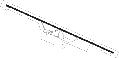
Menongue
Airport details
| Country | Angola |
| State | Cuando Cubango Province |
| Region | FN |
| Airspace | Luanda Ctr |
| Municipality | Menongue |
| Elevation | 4469ft (1362m) |
| Timezone | GMT +1 |
| Coordinates | -14.65758, 17.71983 |
| Magnetic var | |
| Type | land |
| Available since | X-Plane v10.40 |
| ICAO code | FNME |
| IATA code | SPP |
| FAA code | n/a |
Communication
| MENONGUE AFIS | 118.900 |
Nearby beacons
| code | identifier | dist | bearing | frequency |
|---|---|---|---|---|
| VME | MENONGUE VOR/DME | 0.3 | 130° | 114.10 |
Instrument approach procedures
| runway | airway (heading) | route (dist, bearing) |
|---|---|---|
| RW13 | CUCHI (94°) | CUCHI G298J (5mi, 29°) 6300ft |
| RW13 | CUEBE (142°) | CUEBE G298J (5mi, 209°) 6300ft |
| RW13 | G298J (118°) | G298J 8000ft G298J (turn) 6300ft |
| RW13 | TEMBO (118°) | TEMBO G298J (5mi, 118°) 6300ft |
| RNAV | G298J 6300ft G298E (5mi, 118°) 6300ft FNME (6mi, 118°) 4709ft (1372mi, 310°) 5100ft CUEBE (1360mi, 129°) 8000ft | |
| RW31 | BINDA (322°) | BINDA G118J (5mi, 29°) 6300ft |
| RW31 | G118J (298°) | G118J 8000ft G118J (turn) 6300ft |
| RW31 | LUETA (298°) | LUETA G118J (5mi, 298°) 6300ft |
| RW31 | SANDA (274°) | SANDA G118J (5mi, 209°) 6300ft |
| RNAV | G118J 6300ft G118E (5mi, 298°) 6300ft FNME (6mi, 298°) 4721ft (1372mi, 310°) 5100ft SANDA (1382mi, 129°) 8000ft |
Disclaimer
The information on this website is not for real aviation. Use this data with the X-Plane flight simulator only! Data taken with kind consent from X-Plane 12 source code and data files. Content is subject to change without notice.
