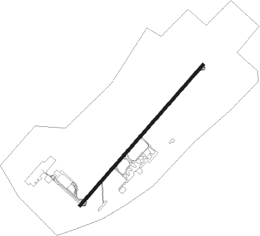
N'djamena - Ndjamena Hassan Djamous
Airport details
| Country | Chad |
| State | Chari-Baguirmi |
| Region | FT |
| Airspace | N'djamena Ctr |
| Municipality | N'Djamena |
| Elevation | 966ft (294m) |
| Timezone | GMT +1 |
| Coordinates | 12.12495, 15.02482 |
| Magnetic var | |
| Type | land |
| Available since | X-Plane v10.40 |
| ICAO code | FTTJ |
| IATA code | NDJ |
| FAA code | n/a |
Communication
| Ndjamena Hassan Djamous Tower | 119.700 |
| Ndjamena Hassan Djamous Approach | 119.700 |
Approach frequencies
| ILS-cat-II | RW05 | 109.9 | 18.00mi |
| 3° GS | RW05 | 109.9 | 18.00mi |
Nearby beacons
| code | identifier | dist | bearing | frequency |
|---|---|---|---|---|
| FL | N'DJAMENA VOR/DME | 1.2 | 39° | 115.30 |
Departure and arrival routes
| Transition altitude | 3000ft |
| STAR starting points | distance | inbound heading | |
|---|---|---|---|
| ALL | |||
| POTE1V | 79.0 | 25° | |
| KELA1V | 23.1 | 85° | |
| SIGA1V | 33.6 | 108° | |
| BOLB1V | 81.1 | 164° | |
| DEPO1V | 81.4 | 179° | |
| KIRB1V | 80.9 | 258° | |
| CHAR1V | 79.7 | 335° | |
| LOSG1V | 79.5 | 354° | |
| RW05 | |||
| POTE1R, POTE1M | 79.0 | 25° | |
| KELA1M, KELA1R | 23.1 | 85° | |
| SIGA1L, SIGA1R | 33.6 | 108° | |
| BOLB1L, BOLB1R | 81.1 | 164° | |
| DEPO1L, DEPO1R | 81.4 | 179° | |
| KIRB6R, KIRB1R | 80.9 | 258° | |
| CHAR6R, CHAR1R | 79.7 | 335° | |
| LOSG6R, LOSG1R | 79.5 | 354° | |
| RW23 | |||
| POTE1N, POTE1B | 79.0 | 25° | |
| KELA1B, KELA1A | 23.1 | 85° | |
| SIGA1A, SIGA1B | 33.6 | 108° | |
| BOLB1B, BOLB1A | 81.1 | 164° | |
| DEPO1B, DEPO1A | 81.4 | 179° | |
| KIRB1N, KIRB1B | 80.9 | 258° | |
| CHAR1B, CHAR1N | 79.7 | 335° | |
| LOSG1N, LOSG1B | 79.5 | 354° | |
Instrument approach procedures
| runway | airway (heading) | route (dist, bearing) |
|---|---|---|
| RW05 | LINOP (70°) | LINOP 3000ft MILRA (5mi, 135°) 3000ft |
| RW05 | MILRA (46°) | MILRA 3000ft |
| RW05 | RELEN (22°) | RELEN 3000ft MILRA (5mi, 315°) 3000ft |
| RNAV | MILRA 3000ft TJ501 (5mi, 46°) 3000ft FTTJ (6mi, 46°) 1017ft TJ502 (5mi, 46°) LINOP (17mi, 243°) 3000ft | |
| RW23 | APOXI (206°) | APOXI 3000ft PONOS (5mi, 135°) 3000ft |
| RW23 | NULOX (247°) | NULOX 3000ft PONOS (5mi, 315°) 3000ft |
| RW23 | PONOS (226°) | PONOS 3000ft |
| RNAV | PONOS 3000ft TJ503 (6mi, 226°) 3000ft FTTJ (8mi, 226°) 1017ft TJ504 (4mi, 226°) APOXI (18mi, 30°) 3000ft |
Holding patterns
| STAR name | hold at | type | turn | heading* | altitude | leg | speed limit |
|---|---|---|---|---|---|---|---|
| BOLB1B | BIMAS | VHF | right | 54 (234)° | 3000ft - 9000ft | DME 5.0mi | 230 |
| BOLB1R | RAKUT | VHF | left | 224 (44)° | 3000ft - 9000ft | 1.0min timed | 230 |
| CHAR1B | BIMAS | VHF | right | 54 (234)° | 3000ft - 9000ft | DME 5.0mi | 230 |
| CHAR1R | RAKUT | VHF | left | 224 (44)° | 3000ft - 9000ft | 1.0min timed | 230 |
| DEPO1B | BIMAS | VHF | right | 54 (234)° | 3000ft - 9000ft | DME 5.0mi | 230 |
| DEPO1R | RAKUT | VHF | left | 224 (44)° | 3000ft - 9000ft | 1.0min timed | 230 |
| IRAG1B | BIMAS | VHF | right | 54 (234)° | 3000ft - 9000ft | DME 5.0mi | 230 |
| IRAG1R | RAKUT | VHF | left | 224 (44)° | 3000ft - 9000ft | 1.0min timed | 230 |
| KELA1B | BIMAS | VHF | right | 54 (234)° | 3000ft - 9000ft | DME 5.0mi | 230 |
| KELA1R | RAKUT | VHF | left | 224 (44)° | 3000ft - 9000ft | 1.0min timed | 230 |
| KIRB1B | BIMAS | VHF | right | 54 (234)° | 3000ft - 9000ft | DME 5.0mi | 230 |
| KIRB1R | RAKUT | VHF | left | 224 (44)° | 3000ft - 9000ft | 1.0min timed | 230 |
| LOSG1B | BIMAS | VHF | right | 54 (234)° | 3000ft - 9000ft | DME 5.0mi | 230 |
| LOSG1R | RAKUT | VHF | left | 224 (44)° | 3000ft - 9000ft | 1.0min timed | 230 |
| POTE1B | BIMAS | VHF | right | 54 (234)° | 3000ft - 9000ft | DME 5.0mi | 230 |
| POTE1R | RAKUT | VHF | left | 224 (44)° | 3000ft - 9000ft | 1.0min timed | 230 |
| SIGA1B | BIMAS | VHF | right | 54 (234)° | 3000ft - 9000ft | DME 5.0mi | 230 |
| SIGA1R | RAKUT | VHF | left | 224 (44)° | 3000ft - 9000ft | 1.0min timed | 230 |
| *) magnetic outbound (inbound) holding course | |||||||
Disclaimer
The information on this website is not for real aviation. Use this data with the X-Plane flight simulator only! Data taken with kind consent from X-Plane 12 source code and data files. Content is subject to change without notice.
