Grootfontein
Airport details
| Country | Namibia |
| State | Otjozondjupa |
| Region | FY |
| Airspace | Windhoek Ctr |
| Elevation | 4636ft (1413m) |
| Timezone | GMT +1 |
| Coordinates | -19.59529, 18.12349 |
| Magnetic var | |
| Type | land |
| Available since | X-Plane v10.40 |
| ICAO code | FYGF |
| IATA code | GFY |
| FAA code | n/a |
Communication
| Grootfontein Tower | 123.300 |
Nearby Points of Interest:
Grave of Axel W Eriksson
-Ghaub Cave
-Second Director's House
-OMEG-Minenbüro
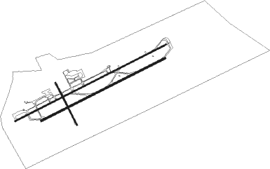
Runway info
Runway 08L / 26R  | ||
| length | 4331m (14209ft) | |
| bearing | 69° / 249° | |
| width | 32m (105ft) | |
| surface | asphalt | |
| blast zone | 0m (0ft) / 128m (420ft) | |
| Runway 08R / 26L | ||
| length | 3562m (11686ft) | |
| bearing | 69° / 249° | |
| width | 45m (148ft) | |
| surface | asphalt | |
| blast zone | 255m (837ft) / 255m (837ft) | |
| Runway 17 / 35 | ||
| length | 1204m (3950ft) | |
| bearing | 157° / 337° | |
| width | 30m (98ft) | |
| surface | asphalt | |
Nearby beacons
| code | identifier | dist | bearing | frequency |
|---|---|---|---|---|
| GFV | GROOTFONTEIN VOR/DME | 0.6 | 207° | 115.70 |
Disclaimer
The information on this website is not for real aviation. Use this data with the X-Plane flight simulator only! Data taken with kind consent from X-Plane 12 source code and data files. Content is subject to change without notice.