Windhoek - Eros
Airport details
| Country | Namibia |
| State | Khomas |
| Region | FY |
| Airspace | Windhoek Ctr |
| Municipality | Windhoek |
| Elevation | 5575ft (1699m) |
| Timezone | GMT +1 |
| Coordinates | -22.60159, 17.08006 |
| Magnetic var | |
| Type | land |
| Available since | X-Plane v10.40 |
| ICAO code | FYWE |
| IATA code | ERS |
| FAA code | n/a |
Communication
| Eros Apron | 121.700 |
| Eros Tower | 118.700 |
Nearby Points of Interest:
Ten-man House
-War Memorial
-Elisabeth House
-Old German School Building
-Look-Out Post
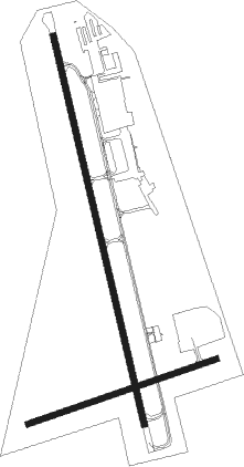
Runway info
Runway 01 / 19  | ||
| length | 1992m (6535ft) | |
| bearing | 351° / 171° | |
| width | 30m (98ft) | |
| surface | asphalt | |
| blast zone | 148m (486ft) / 120m (394ft) | |
| Runway 09 / 27 | ||
| length | 997m (3271ft) | |
| bearing | 77° / 257° | |
| width | 30m (98ft) | |
| surface | asphalt | |
Nearby beacons
| code | identifier | dist | bearing | frequency |
|---|---|---|---|---|
| WHV | WINDHOEK VOR/DME | 22.9 | 72° | 114.50 |
Instrument approach procedures
| runway | airway (heading) | route (dist, bearing) |
|---|---|---|
| RW01 | ISAAC (351°) | ISAAC WE01I (5mi, 351°) 9000ft |
| RW01 | TILLY (17°) | TILLY WE01I (5mi, 82°) 9000ft |
| RNAV | WE01I 9000ft WE01F (6mi, 350°) 7910ft FYWE (6mi, 352°) 5625ft WEM01 (4mi, 349°) TILLY (16mi, 190°) 10000ft TILLY (turn) 10000ft | |
| RW19 | DUMSO (195°) | DUMSO WE19I (5mi, 262°) 8500ft |
| RW19 | KAPPI (170°) | KAPPI WE19I (5mi, 171°) 8500ft |
| RW19 | TEXET (146°) | TEXET WE19I (5mi, 82°) 8500ft |
| RNAV | WE19I 8500ft WE19F (6mi, 170°) 7500ft WE19M (5mi, 171°) 5911ft WEM02 (9mi, 171°) TEXET (20mi, 335°) 10000ft TEXET (turn) 10000ft |
Disclaimer
The information on this website is not for real aviation. Use this data with the X-Plane flight simulator only! Data taken with kind consent from X-Plane 12 source code and data files. Content is subject to change without notice.