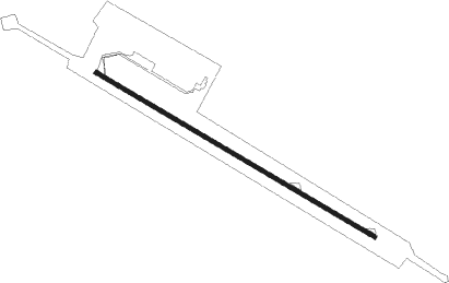
Kisangani - Bangoka Intl
Airport details
| Country | Congo |
| State | Tshopo |
| Region | FZ |
| Airspace | Kinshasa Ctr |
| Municipality | Kisangani |
| Elevation | 1416ft (432m) |
| Timezone | GMT +2 |
| Coordinates | 0.48168, 25.33796 |
| Magnetic var | |
| Type | land |
| Available since | X-Plane v10.40 |
| ICAO code | FZIC |
| IATA code | FKI |
| FAA code | n/a |
Communication
| Bangoka INTL Tower | 121.100 |
| Bangoka INTL Approach | 125.900 |
| Bangoka INTL Approach | 130.900 |
Runway info
| Runway 13 / 31 | ||
| length | 3497m (11473ft) | |
| bearing | 125° / 305° | |
| width | 45m (148ft) | |
| surface | asphalt | |
| blast zone | 101m (331ft) / 98m (322ft) | |
Nearby beacons
| code | identifier | dist | bearing | frequency |
|---|---|---|---|---|
| KGI | KISANGANI VOR/DME | 1.4 | 305° | 114.50 |
Departure and arrival routes
| Transition altitude | 5000ft |
| SID end points | distance | outbound heading | |
|---|---|---|---|
| RW12 | |||
| UPUV2A | 18mi | 74° | |
| SONU2A | 11mi | 125° | |
| IBRU2A | 18mi | 175° | |
| RW30 | |||
| UVSA2B | 17mi | 254° | |
| OGOS2B | 11mi | 305° | |
| ATBA2B | 18mi | 355° | |
| STAR starting points | distance | inbound heading | |
|---|---|---|---|
| RW12 | |||
| ARVO2C | 30.1 | 6° | |
| NIGT2C | 29.9 | 76° | |
| NAVO2C | 30.0 | 113° | |
| IBSO2C | 30.1 | 161° | |
| LEVK2C | 30.0 | 241° | |
| RW30 | |||
| EKVA2D | 30.0 | 47° | |
| UMPE2D | 29.9 | 93° | |
| OMIT2D | 30.1 | 182° | |
| IDGE2D | 29.9 | 275° | |
| UVTA2D | 30.1 | 343° | |
Instrument approach procedures
| runway | airway (heading) | route (dist, bearing) |
|---|---|---|
| RW12 | ISBAR (151°) | ISBAR F12C2 (6mi, 205°) 3100ft |
| RW12 | ONKEV (99°) | ONKEV F12C2 (6mi, 45°) 3100ft |
| RW12 | VOMLI (125°) | VOMLI F12C2 (6mi, 125°) 3100ft |
| RNAV | F12C2 3100ft F12F2 (5mi, 125°) 3100ft FZIC (6mi, 125°) 1456ft FZIC (turn) 2500ft ISBAR (14mi, 331°) 5000ft ISBAR (turn) 5000ft | |
| RW30 | AMKIV (279°) | AMKIV F30C2 (6mi, 225°) 3100ft |
| RW30 | INILA (305°) | INILA F30C2 (6mi, 305°) 3100ft |
| RW30 | NASEK (331°) | NASEK F30C2 (6mi, 25°) 3100ft |
| RNAV | F30C2 3100ft F30F2 (5mi, 305°) 3100ft TINOB (3mi, 305°) 2110ft FZIC (3mi, 305°) 1465ft FZIC (turn) 2500ft AMKIV (14mi, 99°) 5000ft AMKIV (turn) 5000ft |
Holding patterns
| STAR name | hold at | type | turn | heading* | altitude | leg | speed limit |
|---|---|---|---|---|---|---|---|
| ARVO2C | ONKEV | VHF | left | 226 (46)° | > 5000ft | 1.0min timed | ICAO rules |
| EKVA2D | NASEK | VHF | right | 204 (24)° | > 5000ft | 1.0min timed | ICAO rules |
| IBSO2C | ISBAR | VHF | right | 24 (204)° | > 5000ft | 1.0min timed | ICAO rules |
| IDGE2D | INILA | VHF | left | 124 (304)° | > 5000ft | 1.0min timed | ICAO rules |
| LEVK2C | ISBAR | VHF | right | 24 (204)° | > 5000ft | 1.0min timed | ICAO rules |
| NAVO2C | VOMLI | VHF | left | 304 (124)° | > 5000ft | 1.0min timed | ICAO rules |
| NIGT2C | ONKEV | VHF | left | 226 (46)° | > 5000ft | 1.0min timed | ICAO rules |
| OMIT2D | AMKIV | VHF | left | 44 (224)° | > 5000ft | 1.0min timed | ICAO rules |
| UMPE2D | NASEK | VHF | right | 204 (24)° | > 5000ft | 1.0min timed | ICAO rules |
| UVTA2D | NASEK | VHF | right | 204 (24)° | > 5000ft | 1.0min timed | ICAO rules |
| *) magnetic outbound (inbound) holding course | |||||||
Disclaimer
The information on this website is not for real aviation. Use this data with the X-Plane flight simulator only! Data taken with kind consent from X-Plane 12 source code and data files. Content is subject to change without notice.
