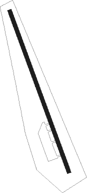
Bukavu Kavuma
Airport details
| Country | Congo |
| State | South Kivu |
| Region | FZ |
| Airspace | Kinshasa Ctr |
| Municipality | Kabare (chefferie) |
| Elevation | 5643ft (1720m) |
| Timezone | GMT +2 |
| Coordinates | -2.31298, 28.80916 |
| Magnetic var | |
| Type | land |
| Available since | X-Plane v10.40 |
| ICAO code | FZMA |
| IATA code | BKY |
| FAA code | n/a |
Communication
| Bukavu Kavuma Tower | 118.900 |
| Bukavu Kavuma Tower | 118.100 |
Runway info
| Runway 17 / 35 | ||
| length | 1999m (6558ft) | |
| bearing | 164° / 344° | |
| width | 45m (148ft) | |
| surface | asphalt | |
Nearby beacons
| code | identifier | dist | bearing | frequency |
|---|---|---|---|---|
| BKV | BUKAVU NDB | 0.2 | 140° | 514 |
| GS | GOMA NDB | 45 | 35° | 397 |
| GOM | GOMA VOR/DME | 46 | 34° | 116.50 |
| RG | RWEGURA NDB | 55.9 | 130° | 305 |
| KW | BUJUMBURA NDB | 56.9 | 150° | 385 |
| BU | BUTARE NDB | 58 | 107° | 340 |
| BN | BUJUMBURA NDB | 63.6 | 152° | 255 |
Departure and arrival routes
| Transition altitude | 14000ft |
| SID end points | distance | outbound heading | |
|---|---|---|---|
| RW17 | |||
| TIPL1B | 37mi | 187° | |
| EBNE1B | 22mi | 226° | |
| RW35 | |||
| TIPL1C | 37mi | 187° | |
| EBNE1C | 22mi | 226° | |
| STAR starting points | distance | inbound heading | |
|---|---|---|---|
| RW35 | |||
| TIPL1A | 37.0 | 7° | |
| EBNE1A | 21.5 | 46° | |
Instrument approach procedures
| runway | airway (heading) | route (dist, bearing) |
|---|---|---|
| RW35 | DOPEM (352°) | DOPEM 11000ft M35C1 (5mi, 359°) 8900ft VOLTO (4mi, 354°) 7500ft |
| RW35 | OSLON (18°) | OSLON 11000ft M35C1 (5mi, 84°) 8900ft VOLTO (4mi, 354°) 7500ft |
| RNAV | VOLTO 7500ft FZMA (5mi, 344°) 5642ft VAKIB (2mi, 354°) 7200ft ATNIB (8mi, 53°) 9000ft ATNIB (turn) |
Holding patterns
| STAR name | hold at | type | turn | heading* | altitude | leg | speed limit |
|---|---|---|---|---|---|---|---|
| EBNE1A | EBNEL | VHF | right | 272 (92)° | 11000ft - 46000ft | 1.0min timed | ICAO rules |
| TIPL1A | TIPLI | VHF | left | 196 (16)° | 11000ft - 46000ft | 1.0min timed | ICAO rules |
| *) magnetic outbound (inbound) holding course | |||||||
Disclaimer
The information on this website is not for real aviation. Use this data with the X-Plane flight simulator only! Data taken with kind consent from X-Plane 12 source code and data files. Content is subject to change without notice.
