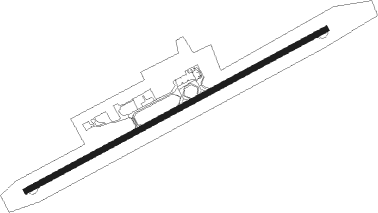
Lubumbashi - Lubumbashi Intl
Airport details
| Country | Congo |
| State | Haut-Katanga |
| Region | FZ |
| Airspace | Kinshasa Ctr |
| Municipality | Kimbembe |
| Elevation | 4292ft (1308m) |
| Timezone | GMT +2 |
| Coordinates | -11.59128, 27.53090 |
| Magnetic var | |
| Type | land |
| Available since | X-Plane v10.40 |
| ICAO code | FZQA |
| IATA code | FBM |
| FAA code | n/a |
Communication
| Lubumbashi Intl Ground Control | 121.900 |
| Lubumbashi Intl Tower | 118.100 |
Approach frequencies
| ILS-cat-I | RW07 | 109.9 | 18.00mi |
| 3° GS | RW07 | 109.9 | 18.00mi |
Runway info
| Runway 07 / 25 | ||
| length | 3200m (10499ft) | |
| bearing | 67° / 247° | |
| width | 50m (164ft) | |
| surface | asphalt | |
| blast zone | 65m (213ft) / 63m (207ft) | |
Nearby beacons
| code | identifier | dist | bearing | frequency |
|---|---|---|---|---|
| LUB | LUBUMBASHI VOR/DME | 1.6 | 247° | 116.70 |
Departure and arrival routes
| Transition altitude | 8000ft |
| SID end points | distance | outbound heading | |
|---|---|---|---|
| RW07 | |||
| BEMB1A | 22mi | 13° | |
| SOBT1A | 124mi | 43° | |
| BESH1A | 30mi | 144° | |
| MOTA1A | 25mi | 171° | |
| RW25 | |||
| SOBT1B | 124mi | 43° | |
| BESH1B | 30mi | 144° | |
| MOTA1B | 25mi | 171° | |
| EXUT1B | 15mi | 290° | |
| STAR starting points | distance | inbound heading | |
|---|---|---|---|
| RW07 | |||
| UVTO1C | 30.0 | 126° | |
| BESH1C | 30.2 | 324° | |
| MOTA1C | 24.8 | 351° | |
| RW25 | |||
| IBLE1D | 30.0 | 219° | |
| AKUG1D | 30.0 | 237° | |
| BESH1D | 30.2 | 324° | |
| MOTA1D | 24.8 | 351° | |
Instrument approach procedures
| runway | airway (heading) | route (dist, bearing) |
|---|---|---|
| RW07 | BAPVA (89°) | BAPVA 8600ft Q07C1 (5mi, 146°) 6100ft |
| RW07 | DIKVO (44°) | DIKVO 8600ft Q07C1 (5mi, 346°) 6100ft |
| RW07 | GILEK (67°) | GILEK 8600ft Q07C1 (5mi, 67°) 6100ft |
| RNAV | Q07C1 6100ft Q07F2 (4mi, 67°) 6100ft FZQA (6mi, 67°) 4351ft LETNU (11mi, 67°) NIKMU (9mi, 157°) DIKVO (23mi, 258°) 7100ft | |
| RW25 | KINDO (232°) | KINDO 9280ft Q25C1 (5mi, 175°) 7570ft |
| RW25 | LONVO (277°) | LONVO 9280ft Q25C1 (5mi, 335°) 7570ft |
| RW25 | OMABO (254°) | OMABO 9280ft Q25C1 (5mi, 255°) 7570ft |
| RNAV | Q25C1 7570ft Q25F1 (5mi, 255°) 5880ft FZQA (6mi, 253°) 4277ft OLBOT (9mi, 257°) SOMVI (9mi, 165°) LONVO (21mi, 63°) 6000ft LONVO (turn) |
Holding patterns
| STAR name | hold at | type | turn | heading* | altitude | leg | speed limit |
|---|---|---|---|---|---|---|---|
| AKUG1D | OMABO | VHF | right | 78 (258)° | > 6000ft | 1.0min timed | ICAO rules |
| BESH1C | DIKVO | VHF | right | 171 (351)° | 7100ft - 10000ft | 1.0min timed | 230 |
| BESH1D | LONVO | VHF | right | 158 (338)° | > 6000ft | 1.0min timed | ICAO rules |
| IBLE1D | OMABO | VHF | right | 78 (258)° | > 6000ft | 1.0min timed | ICAO rules |
| LARU1D | KINDO | VHF | right | 358 (178)° | > 6000ft | 1.0min timed | ICAO rules |
| MOTA1C | DIKVO | VHF | right | 171 (351)° | 7100ft - 10000ft | 1.0min timed | 230 |
| MOTA1D | LONVO | VHF | right | 158 (338)° | > 6000ft | 1.0min timed | ICAO rules |
| NILM1C | BAPVA | VHF | left | 331 (151)° | 7100ft - 10000ft | 1.0min timed | 230 |
| NILM1D | KINDO | VHF | right | 358 (178)° | > 6000ft | 1.0min timed | ICAO rules |
| OSME1C | BAPVA | VHF | left | 331 (151)° | 7100ft - 10000ft | 1.0min timed | 230 |
| UVTO1C | BAPVA | VHF | left | 331 (151)° | 7100ft - 10000ft | 1.0min timed | 230 |
| VEGA1C | GILEK | VHF | right | 251 (71)° | 7100ft - 10000ft | 1.0min timed | 230 |
| *) magnetic outbound (inbound) holding course | |||||||
Disclaimer
The information on this website is not for real aviation. Use this data with the X-Plane flight simulator only! Data taken with kind consent from X-Plane 12 source code and data files. Content is subject to change without notice.
