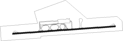
Airports for X-Plane offers a convenient way to explore airports and their related communication information for the X-Plane flight simulator. It only uses data from the X-Plane flight simulator itself, and is therefore more reliable than the data that comes from real aviation websites. You can search for airports by using the ICAO code, or browse for airports per country and state. The information displayed is categorized by airport details, runway information, airport communication, approach frequencies (ILS and Glidepath details), details of nearby beacons, SIDs, STARs and approach procedures.

nearby airplane tarmac runway flight military non-towered airport stolport airfield traffic pattern airdrome warfare passenger aerodrome gravel air safety arriving passengers airline airport check-in city

Fes - Saiss

Airport details

CountryMorocco
StateFès Province
RegionGM
AirspaceCasablanca Ctr
MunicipalityOuled Tayeb
Elevation1897ft (578m)
TimezoneGMT +0
Coordinates33.92722, -4.97778
Magnetic var
Typeland
Available sinceX-Plane v10.40
ICAO codeGMFF
IATA codeFEZ
FAA coden/a

Communication

Saiss Tower118.600

Approach frequencies

ILS-cat-IRW27109.718.00mi
3° GSRW27109.718.00mi
Nearby Points of Interest:
Southern Tower (Fes)
-
Bab el-Semarine
-
Fes Jdid
-
Al-Hamra Mosque
-
Bab Lhadid
-
Bab Dekkakin
-
El Glaoui Palace, Fez
-
Bab Segma
-
Medina of Fez
-
Dar al-Magana
-
Dar Adiyel
-
Bab Mahrouk
-
El-Oued Mosque
-
Kasbah of Cherarda
-
Sahrij Madrasa
-
Riad Ba Mohamed Chergui
-
Cherratine Madrasa
-
Fondouk Chemaine
-
Funduq al-Najjariyyin
-
Quaraouyine Mosque
-
Foundouk Tetouaniyine
-
Medersa Al Mesbahia
-
Bab Guissa Mosque
-
Sidi Ahmed al-Tijani Zawiya
-
El-Jamai Palace

Runway info

Runway 09 / 27
 length3194m (10479ft)
 bearing90° / 270°
 width45m (148ft)
 surfaceasphalt
 displ threshold0m (0ft) / 218m (715ft)
 blast zone60m (197ft) / 62m (203ft)

Airport layout


Taxiway locations
Parking locations

Nearby beacons

codeidentifierdistbearingfrequency
FESFES VOR/DME1.7270°115.70
FEZSAISS (FES) NDB4.390°315
MKSMEKNES VOR27265°116.30
IFNIFRANE NDB27.2203°409
CNVTOUAHAR NDB42.971°270

Disclaimer

The information on this website is not for real aviation. Use this data with the X-Plane flight simulator only! Data taken with kind consent from X-Plane 12 source code and data files. Content is subject to change without notice.